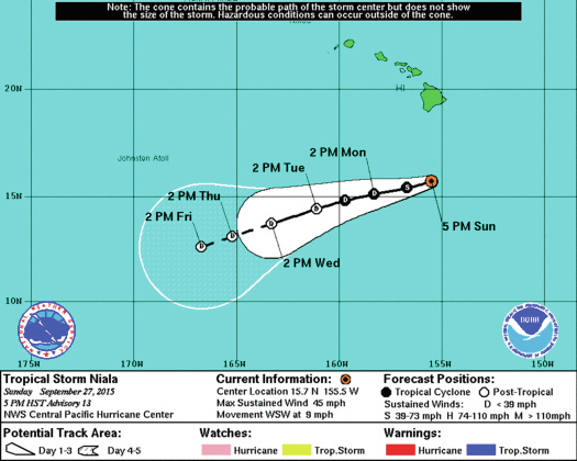
Tropical Storm Niala, which passed a couple hundred miles south of the Big Island Sunday, is forecast to continue weakening in the coming days. ADVERTISING Tropical Storm Niala, which passed a couple hundred miles south of the Big Island Sunday,
Tropical Storm Niala, which passed a couple hundred miles south of the Big Island Sunday, is forecast to continue weakening in the coming days.
Located 280 miles south of Kailua-Kona as of 5 p.m. Sunday, Niala had maximum sustained winds of 45 mph and was tracking west-southwest at 9 mph, according to Central Pacific Hurricane Center forecasters based in Honolulu. Tropical storm-force winds extended outward up to 60 miles from its center.
Niala is expected to weaken to a tropical depression sometime Monday and to a post-tropical remnant low by Tuesday evening as the storm encounters wind shear. Forecasters did note, however, that Niala could restrengthen in seven to 10 days when it reaches an area favorable for development. By that time the storm would be far west-southwest of the state.
A tropical storm watch, posted Friday for the Big Island, was dropped early Sunday. A flash flood watch remained posted through late Sunday, according to the National Weather Service in Honolulu. The threat of heavy rain was expected to diminish Monday morning.
Forecasters cautioned that while there are no watches, warnings or advisories associated with Niala in effect, there continues to be “real hazards” across the Hawaiian Islands because of moisture and swells brought in by strong trade winds. A high surf advisory for the island’s east-facing shores was to lapse at 6 a.m. Monday.
Elsewhere in the Central Pacific, no tropical cyclones are expected to develop through Tuesday afternoon. The Central Pacific covers an area spanning west of 140 degrees west longitude to the international date line. Hawaii falls within this area.
In the Eastern Pacific, Tropical Storm Marty prompted a tropical storm watch for areas of Mexico’s southwestern coast on Sunday. Located 190 miles west-southwest of Acapulco, Mexico, the storm was circulating 65 mph winds and tracking north at 2 mph, according to the National Hurricane Center in Miami.
On its current forecast track, the center of the storm is forecast to approach but remain offshore of the Mexican coast, forecasters said. Forecasters expected to upgrade the tropical storm watch to a warning for areas of the Mexico coast, from Acapulco to Lazaro Cardena, early Monday. Marty is expected is expected to drench areas of the Mexican state of Guerror through Thursday. Rainfall totals are expected to be between 6 and 12 inches, however, isolated areas in the Sierra Madre del Sur mountains could see up to 20 inches.
Forecasters are also watching an area of low pressure expected to develop several hundreds miles south-southwest of the southern tip of the Baja California peninsula. The system should have a chance to develop around the middle of the week before upper-level winds inhibit further organization by the end of the week.
Elsewhere in the Eastern Pacific, no tropical cyclones are expected to develop during the coming five days, according to forecasters.
The Central and Eastern Pacific hurricane seasons continue through Nov. 30.
Get more hurricane-related content, including preparation tips, evacuation info and daily tropical weather updates, on our hurricane season page, sponsored by Clark Realty, at www.westhawaiitoday.com/hurricane-season-2015.


