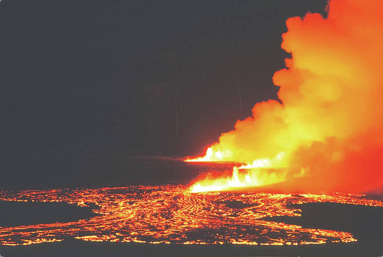
Volcano Watch: New Year’s Eve 1974: Kilauea’s most recent Southwest Rift Zone eruption
Kilauea is one of the most active volcanoes on Earth, with a majority of its eruptions occurring at its summit or one of its two rift zones, the East Rift Zone and Southwest Rift Zone. The Southwest Rift Zone hasn’t erupted since New Year’s Eve 1974, almost exactly 49 years ago.
Recent activity at Kilauea has been concentrated at the summit (2008–2018 and 2020–2023 eruptions), middle East Rift Zone at Pu‘u‘o‘o (1983–2018), and the lower East Rift Zone eruption (2018). These eruptions have all demonstrated Kilauea’s awe-inspiring behavior, with sometimes tragic impacts.
Now is an apt time to revisit the 1974 Southwest Rift Zone eruption in the wake of the recent elevated seismicity in similar areas. Elevated earthquake activity, sometimes over 100 earthquakes a day, has been occurring since early October in the south caldera and Southwest Rift Zone regions of Kilauea.
Kilauea erupted three times in 1974; twice at the summit — in July and September — and once from the Southwest Rift Zone in December. Immediately following the September 1974 summit eruption, the summit region of Kilauea started undergoing very high rates of inflation (approximately 30 microradians of ground tilt from September to December).
Seismicity increased in the summit and upper East Rift Zone regions for the month leading up to the December eruption. By the evening of December 30, the summit and upper Southwest Rift Zone were experiencing earthquakes at a rate of 2–4 per minute. Just after midnight, at 12:10 a.m. HST on December 31, the USGS Hawaiian Volcano Observatory (HVO) seismic alarm sounded, tiltmeters recorded sharp deflation, and increased tremor indicated that magma was on the move out of the summit region.
HVO staff did not have long to wait, with the first lava fountains observed on New Year’s Eve at 2:56 a.m. HST in the Ka‘u Desert region of Hawaii Volcanoes National Park. These lava fountains reached average heights of 115–130 feet (35–40 meters), but on rare occasions threw lava bombs up to 330 feet (100 meters) high. Over 10 fissures eventually opened during the first hour of the eruption, to the east-northeast and west-southwest, forming a near-continuous fountain of lava that stretched over 2.5 miles (4.2 kilometers) long.
Lava fountain heights started to rapidly decline throughout the morning and the eruption was over by 8:50 a.m. HST. Despite the short duration of this eruption — only about six hours — lava managed to flow approximately 7.5 miles (12 kilometers) from source fountains, emplacing an uncommonly thin (typically less than 1 meter or 3 feet thick) lava flow across a large area of the upper Southwest Rift Zone.
HVO continues to monitor the ongoing unrest in the summit and Southwest Rift Zone regions of Kilauea, with increased rates of earthquakes and ground deformation indicating that magma is moving in this area. You can learn about this activity in the Kilauea updates that are posted daily at https://www.usgs.gov/volcanoes/kilauea/volcano-updates.
Whether this increase in activity over the past several months is a prelude to a new eruption in the Southwest Rift Zone in the near future, or if another summit eruption will occur is not possible to forecast currently. However, the Southwest Rift Zone remains an active part of Kilauea that will experience lava flows in the future.
Volcano Activity Updates
Kilauea is not erupting. Its USGS Volcano Alert level is ADVISORY.
The unrest associated with the intrusion that began in early October southwest of Kilauea’s summit continues. Earthquake activity in Kilauea’s summit region over the past week remained relatively low. The Uekahuna tiltmeter — located northwest of the caldera — showed several microradians of net tilt over the past week, as did the Sand Hill tiltmeter — located southwest of the caldera. Unrest may continue to wax and wane with changes to the input of magma into the area and eruptive activity could occur in the near future with little or no warning. The most recent sulfur dioxide (SO2) emission rate for the summit — approximately 70 tonnes per day — was measured on December 5.
Mauna Loa is not erupting. Its USGS Volcano Alert Level is at NORMAL.
Webcams show no signs of activity on Mauna Loa. Summit seismicity has remained at low levels over the past month. Ground deformation indicates continuing slow inflation as magma replenishes the reservoir system following the 2022 eruption. SO2 emission rates are at background levels.
Three earthquakes were reported felt in the Hawaiian Islands during the past week: a M3.4 earthquake 14 km (8 mi) SW of Volcano at 27 km (16 mi) depth on Dec. 23 at 4:42 HST p.m., a M4.0 earthquake 13 km (8 mi) SW of Volcano at 27 km (17 mi) depth on Dec. 23 at 4:27 p.m. HST, a M2.9 earthquake 15 km (9 mi) S of Volcano at 1 km (0 mi) depth on Dec. 23 at 12:51 p.m. HST.
HVO continues to closely monitor Kilauea and Mauna Loa.
Please visit HVO’s website for past Volcano Watch articles, Kilauea and Mauna Loa updates, volcano photos, maps, recent earthquake information, and more. Email questions to askHVO@usgs.gov.
Volcano Watch is a weekly article and activity update written by U.S. Geological Survey Hawaiian Volcano Observatory scientists and affiliates.


