Volcano Watch: Unrest continues at Kilauea summit
The most recent eruption at Kilauea’s summit began on Sunday, Sept. 10. Following weeks of heightened unrest, fissures opened on the Halema’uma’u crater floor and to the east on the “down dropped block,” a remnant of the older caldera floor that collapsed in 2018.
The eruption was short lived, ending just a week later, on Sept. 16. Lava stopped flowing. Gas emissions diminished. Seismicity and ground deformation returned to “background” levels. Things got quiet. But not for long.
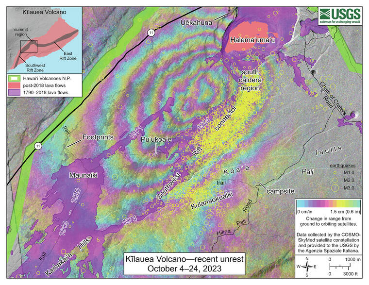
A new series of earthquake swarms began suddenly at Kilauea’s summit on Oct. 4. Activity escalated quickly and more than 250 earthquakes were recorded in the south caldera region on Oct. 5. Seismicity at this scale has been observed prior to recent Kilauea summit eruptions, but as we know a new eruption did not begin in early October.
Instead, intermittent seismic swarms have continued, varying from less than 20 events per day to more than 150 events on Oct. 22. Most earthquakes have been smaller than magnitude-2 and have occurred at depths of around 1 to 3 km (0.6 to 2 mi) below the surface. Seismic signals indicating magma movement — such as low-frequency tremor — have also been observed, most recently on Oct. 23.
Ground deformation rates increased in early October as well. The Sand Hill tiltmeter, located southwest of the caldera, has recorded approximately 120 microradians of change over the past three weeks. GPS and satellite radar data confirm that over 10 cm (4 in) of uplift has occurred in the south caldera region since late September. Northeast of the caldera, the Uekahuna tiltmeter has recorded approximately 20 microradians of change over the past three weeks.
Deformation has also been intermittent, with days-long periods of increased rates alternating with similar-duration periods of little or no displacement. Increased numbers of earthquakes have generally coincided with increased rates of ground motion at Sand Hill, as seen on October 4–6, 16–18, and 21–23.
These observations indicate that magma is accumulating in the geologically complex south caldera region. Examining history, this is not surprising.
Numerous intrusions have been recorded here in the past, most recently in 2021 and 2015. In August 2021, an intrusion here occurred over about a week and was followed by an eruption within Halema‘uma‘u about a month later on Sept. 29. In May 2015, an intrusion here lasted less than a week and occurred during ongoing eruptions within Halema‘uma‘u and at Pu‘u‘o‘o.
Intrusions also occurred here in the 1960s, 1970s, early 1980s, and in 2006. But only one, in December 1974, led to an eruption. It migrated southward from the caldera and then reached the surface, erupting as a series of short fissure segments with a total length of 5 km (3 mi), as it turned southwest. Of note is the fact that, before the 1974 eruption, earthquakes had migrated farther southwest than HVO has observed during recent unrest.
Although it is not possible to forecast an exact outcome from current unrest, here are three possible scenarios that could play out in the coming days to weeks.
Magma could continue to accumulate but eventually stop, with no eruption.
Or, magma could continue to accumulate, followed by a summit eruption inside the caldera — similar to recent eruptions at Halema‘uma‘u. If this happens, we expect to see accelerating deformation and seismicity beneath the caldera 1 to 2 hours before an eruption.
Or, magma could continue to accumulate, with an eventual summit eruption outside the caldera, to the south or southwest. If this happens, we expect to see earthquakes migrating southward as they did in December 1974, followed by accelerating deformation and seismicity 1 to 2 hours before an eruption.
The timeframe for any scenario is uncertain. With permission from Hawai‘i Volcanoes National Park, HVO has installed two new webcams to better monitor the south caldera region. Considering potential volcanic hazards, the National Park has closed trails near areas of unrest.
Unrest continues at Kilauea summit. HVO is watching closely. Time will tell what happens next!
Volcano Activity Updates
Kilauea is not erupting. Its USGS Volcano Alert level is ADVISORY.
The area just south of Kilauea’s summit continues to show signs of episodic unrest. Overall, inflation at the summit of Kilauea remains high and has surpassed the level seen just before the most recent eruption on Sept. 10. Seismicity in the region south of Kilauea caldera summit continues, though at decreased rates from the peak in activity on Oct. 6. The most recent sulfur dioxide (SO2) emission rate, of approximately 100 tonnes per day, was measured on Oct. 19.
Mauna Loa is not erupting. Its USGS Volcano Alert Level is at NORMAL.
Webcams show no signs of activity on Mauna Loa. Seismicity remains low. Summit ground deformation rates indicate slow inflation as magma replenishes the reservoir system following the recent eruption. SO2 emission rates are at background levels.
Two earthquakes were reported felt in the Hawaiian Islands during the past week: a M29 earthquake 1 km (1 mi) WSW of Pahala at 32 km (20 mi) depth on Oct. 23 at 7:37 p.m. HST and a M3.5 earthquake 11 km (6 mi) NE of Pahala at 31 km (19 mi) depth on Oct. 19 at 5:09 p.m. HST.
HVO continues to closely monitor Kilauea and Mauna Loa.
Please visit HVO’s website for past Volcano Watch articles, Kilauea and Mauna Loa updates, volcano photos, maps, recent earthquake information, and more. Email questions to askHVO@usgs.gov.
Volcano Watch is a weekly article and activity update written by U.S. Geological Survey Hawaiian Volcano Observatory scientists and affiliates.


