Understanding the eruptive history of volcanoes in Hawaii requires a tremendous amount of time and effort examining deposits. Typically, older eruptions have less material exposed at the surface because younger eruptions bury them, or wind and rain erode them. Such is the case for one of Kilauea’s largest explosive eruptions, which is not exposed near its source at the summit and must be studied further afield.
Although Kilauea is world renowned for its lava flow eruptions, it also has a history of explosive eruptions. The two most recent explosive periods, which created deposits named the Uwekahuna Ash and Keanakako’i Tephra, were preceded by huge outpourings of lava. These large lava flow eruptions may have drained Kilauea’s summit plumbing system and caused caldera collapse; subsequent activity was explosive.
Studies of the younger Keanakaako’i Tephra (1500 to the early 1820s Common Era, or CE) have provided many key insights into Kilauea’s evolution over the past few hundred years.
The older Uwekahuna Ash represents possibly 1,200 years of dominantly explosive activity, yet only a few detailed geologic studies exist for these deposits. The type locality of Uwekahuna Ash was a vertical section within the Uekahuna bluff on the western wall of Kaluapele (Kilauea’s summit caldera), but summit collapses in 2018 and subsequent rock falls buried this location. Fortunately, we can study samples that were collected from this location and collect new samples from the same deposits further away from the summit.
The Kulanaokuaiki Tephra is a subset of the Uwekahuna Ash. It erupted between 400–1000 CE. HVO geologists and collaborators are focusing on one part of this deposit—named Kulanaokuaiki-3 (K-3, for short)—because it is one of the largest known explosive eruptions at Kilauea in the past several thousand years.
K-3 explosive activity likely had an eruption column that reached 14–18 km (9–10 miles) above sea level for several hours. The K-3 plume dispersed tephra, in a southeast direction, across an area larger than 65 square km (16,000 acres), from Kilauea’s summit all the way to Halape on the coastline 17 km (10.5 miles) away.
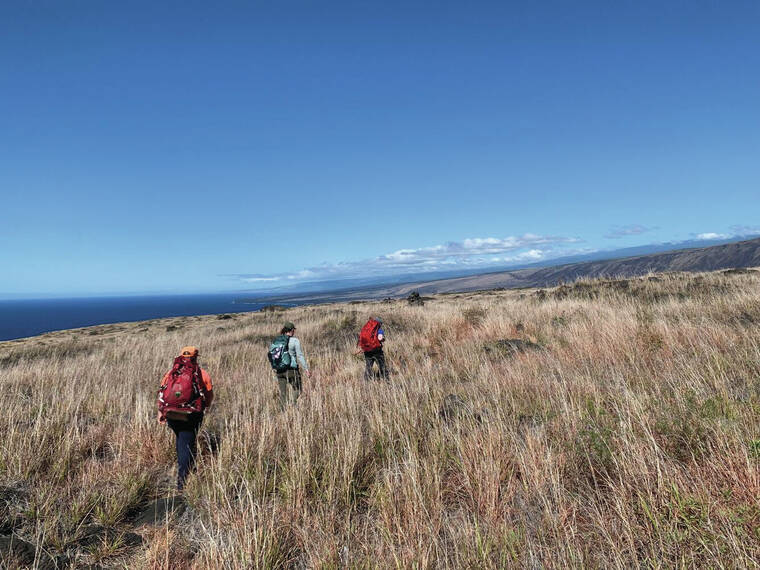
Recently, HVO scientists conducted fieldwork in the backcountry of Hawai‘i Volcanoes National Park (HAVO). They focused on finding, measuring, and sampling deposits from K-3 to better understand how, when, and why eruptions of this magnitude might occur. This work was conducted under the supervision of a HAVO archaeologist, who ensured our work would not disrupt any cultural or natural resources.
In the field, HVO geologists dug small pits in soil and tephra that has accumulated in the low spots on the lava flows that cover the surface of Kilauea’s south flank. Once exposed, the layers of soil, ash, and tephra within the pits were measured, described, and sampled.
Using these samples we’ll assess the degree of tephra fragmentation—a proxy for eruption intensity and size—by measuring the shape and size distribution of tephra grains using state-of-the-art analytical equipment in the HVO Tephra Lab. Magma degassing during the eruption will be evaluated by measuring tephra density using a high-precision pycnometer and/or 3D scanner in the HVO Tephra Lab. Using microscopes, we’ll investigate how much of the sample is fresh versus recycled older lava. These physical parameters will help us to understand the K-3 deposit, and the eruptions that created it.
Kilauea has not had an explosive eruption as large as the K-3 in modern times. It’s important to evaluate what generates such large eruptions because a similar eruption today would be devastating to communities surrounding Kilauea summit and downwind. Another K-3 sized eruption would likely inject volcanic ash into the subtropical jet stream and disrupt regional air traffic.
While Kilauea’s lava flows are often in the limelight, HVO geologists are continuing to study the deposits from past explosive eruptions. The samples we collect and datasets we generate from them provide an important framework for interpreting modern monitoring signals, allowing us to better characterize Kilauea’s eruptive behavior.
Volcano Activity Updates
Kilauea is not erupting. Its USGS Volcano Alert level is ADVISORY.
Active lava has not been visible within Halema’uma’u crater at the summit of Kilauea since June 19. Earthquake activity in the summit region remained slightly increased over the past week. Summit tiltmeters generally showed inflation over the past week. A sulfur dioxide (SO2) emission rate of approximately 120 tonnes per day was measured on August 6.
Mauna Loa is not erupting. Its USGS Volcano Alert Level is at NORMAL.
Webcams show no signs of activity on Mauna Loa. Seismicity remains low. Summit ground deformation rates indicate slow inflation as magma replenishes the reservoir system following the recent eruption. SO2 emission rates are at background levels.
There were three earthquakes with three or more felt reports in the Hawaiian Islands during the past week: a M3.2 earthquake 4 km (2 mi) S of Volcano at 2 km (1 mi) depth on August 9 at 10:40 a.m. HST, a M3.6 earthquake 4 km (2 mi) NNE of Wai‘ohinu at 12 km (7 mi) depth on August 4 at 8:30 p.m. HST, and a M3.9 earthquake 69 km (42 mi) WNW of Kalaoa at 43 km (26 mi) depth on August 4 at 5:24 a.m. HST.
HVO continues to closely monitor Kilauea and Mauna Loa.
Please visit HVO’s website for past Volcano Watch articles, Kilauea and Mauna Loa updates, volcano photos, maps, recent earthquake information, and more. Email questions to askHVO@usgs.gov.
Volcano Watch is a weekly article and activity update written by U.S. Geological Survey Hawaiian Volcano Observatory scientists and affiliates. This week’s article was written by Hawaiian Volcano Observatory geologist Kendra J. Lynn.


