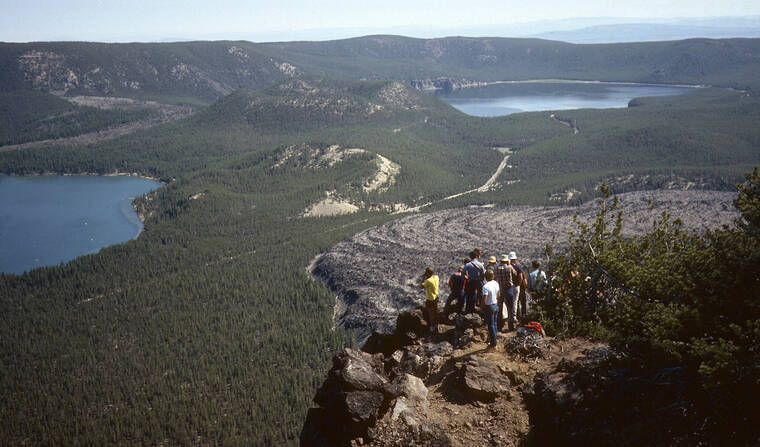
Lava flows erupted at Newberry cover an area larger than Rhode Island. Powerful explosive eruptions sent volcanic ash into Idaho and the San Francisco Bay Area. A deep caldera indents its summit, hosting a flow of obsidian and thick beds of explosive pumice.
Do you know where Newberry Volcano is?
Newberry is southeast of Bend, Oregon, and in fact basalt flows and cinder cones in Bend are part of the volcano. Most visitors to the booming city head west to ski at Mount Bachelor or hike in the Three Sisters area, a clustering of volcanoes in the Cascade Range. They may not notice Newberry, because of its broad shape unlike most steep Cascade volcanoes, although it stands 4,270 feet above its surroundings.
A recently completed, exhaustive study of Newberry by USGS geologist Julie Donnelly-Nolan and her colleagues shows that Newberry should be considered an eastern bulge of the Cascades volcanic arc. Its position 37 miles east of the Cascade axis enables sweeping views of the volcanic range from the top of Paulina Peak, 7,984 feet high, on the south rim of the caldera.
From the summit on an exceptionally clear day, you can see from Mount Adams in southern Washington to Mount Shasta in northern California, a reach of nearly 310 miles. More than 1,640 feet below Paulina Peak lies the beautiful caldera with its two lakes and the geologic wonder of the Big Obsidian Flow. Then you can drive into the caldera to see these features up close.
A wide range of volcanic rocks characterizes Newberry. One important rock type is basalt, complete with extensive lava tubes and cinder cones familiar to us in Hawaii. Basaltic andesite, similar to basalt but richer in silica, is more common, as in the Cascades volcanoes farther west, and Donnelly-Nolan mapped hundreds of basalt and basaltic andesite vents on the edifice. Dacite and rhyolite, still richer in silica and potentially very explosive but very rare in Hawai`i, complete the rock types. The Big Obsidian Flow has a rhyolite composition.
Newberry Volcano formed at the western end of the High Lava Plains, a broad volcanic region of basalt and rhyolite in southeastern Oregon that forms the northern sub-province of the extensional Basin and Range Province, best known in Nevada.
Newberry has the appearance of a shield volcano such as Mauna Loa, but this is misleading and overlooks its silicic explosive history. It is best characterized as a composite volcano like large volcanoes in Iceland.
Newberry developed where the northwest corner of the Basin and Range Province merges with the Cascades. Tectonic extension plays a significant role at Newberry and exerts strong control on vent alignments, which typically parallel fault trends. The caldera is at the intersection of fault systems of the High Lava Plains and Basin and Range, and the size and longevity of Newberry may reflect pathways to the surface created by this intersection.
Throughout its lifetime, Newberry has been the most explosive volcano in the Cascades, with at least 5 caldera-forming eruptions in less than 300,000 years. The most recent caldera developed about 65,000 years ago, when explosive eruption of basaltic andesite to rhyolite created the current 3.7 by 5 miles caldera.
Several eruptions have occurred in the caldera since the last glacier melted nearly 12,000 years ago, the youngest of which, about 1,300 years old, produced the Big Obsidian Flow and a tephra that has been found in Idaho.
Newberry has one sibling in the Cascades. Donnelly-Nolan previously mapped the similar Medicine Lake volcano in northern California, about 200 km (120 miles) south of Newberry and east of the Cascade axis. Both large volcanoes provide the opportunity to visit a wide variety of young lava flows.
Seismic and geodetic monitoring has detected no unrest at Newberry. Eventually, though, the volcano will erupt again, and Newberry will be rightfully recognized among the nation’s most hazardous volcanoes.
Volcano Activity Updates
Kilauea is erupting. Its USGS Volcano Alert level is at WATCH. Kilauea updates are issued daily.
Kilauea volcano’s summit eruption in Halemaʻumaʻu crater within Hawaii Volcanoes National Park continues. Activity is concentrated in a large lava lake in the eastern half of the crater, as well as a smaller lake to the west, in the basin of the 2021-22 lava lake. Summit tilt has shown several deflation/inflation trends over the past week. Summit earthquake activity remains low and eruptive tremor (a signal associated with fluid movement) is present. A sulfur dioxide emission rate of 3,500 tonnes per day was measured on Jan. 9. For Kilauea monitoring data, see https://www.usgs.gov/volcanoes/kilauea/past-week-monitoring-data-kilauea.
Mauna Loa is not erupting. Its USGS Volcano Alert Level is at ADVISORY. Mauna Loa updates are issued weekly on Thursdays.
Webcams show no signs of activity on Mauna Loa. Seismicity remains low. Ground deformation rates and sulfur dioxide (SO2) emission rates are at background levels. For Mauna Loa monitoring data, see: https://www.usgs.gov/volcanoes/mauna-loa/monitoring-data.
There were three earthquakes with 3 or more felt reports in the Hawaiian Islands during the past week: a magnitude-2.7 earthquake 8 miles north of Kukuihaele on Jan. 15 at 2:05 a.m., a magnitude-3.3 earthquake 3 mils northwest of Pahala on Jan. 14 at 3:28 p.m., and a magnitude-3.4 earthquake 4 miles east of Pahala on Jan. 12 at 8:11 p.m.
Visit https://www.usgs.gov/observatories/hawaiian-volcano-observatory for past Volcano Watch articles, updates, photos, maps, recent earthquake info, and more. Email questions to askHVO@usgs.gov. Volcano Watch is a weekly article and activity update written by USGS Hawaiian Volcano Observatory scientists and affiliates.


