Question: what is arguably one of the most widely recognized volcano names in the world due to its references in the Old Testament?
First hint: most people who know the name probably don’t know it refers to a volcano. Second hint: where do many people think Noah’s Ark landed when the Biblical Great Flood receded?
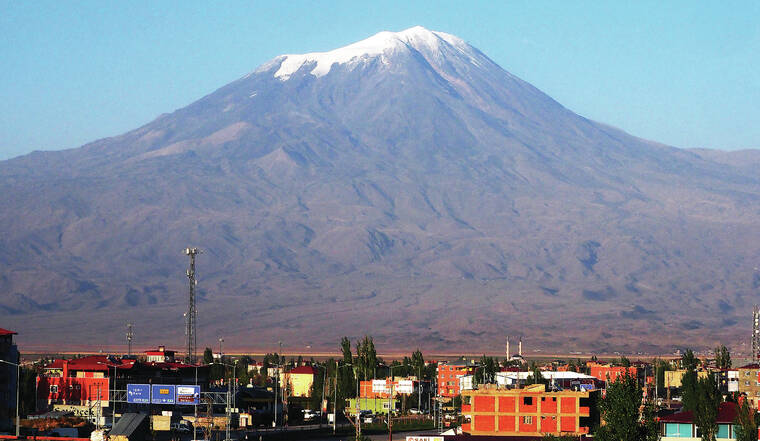
The answer is Mount Ararat, a volcano that rises to an elevation of 16,854 feet and towers over the Armenian Highlands in eastern Turkey near its borders with Iran and Armenia. A small glacier caps the mountain and is currently melting. The volcano dominates the skyline as seen from Yerevan (population 1.1 million), the capital city of Armenia some 40 miles away and 2 miles lower, and it has long been a cultural icon for Armenians.
Mount Ararat comprises two large cones 8 miles apart, Greater and Lesser Ararat. Greater Ararat, the western of the two cones, is about 16 miles wide and rises some 1.9 miles above its surroundings. It is separated from Lesser Ararat (12,782 feet high and 9 miles wide) by a large north-south fault; many smaller cones and lava domes erupted along this fault and on the flanks of the two larger cones.
Mount Ararat began forming about 1.5 million years ago. Eruptions produced thick deposits of explosive debris, including pyroclastic flows, and lava flows with wide-ranging compositions from basalt to rhyolite, resulting in the construction of the two major composite stratovolcanoes.
Greater Ararat remains volcanically active. It last erupted on July 2, 1840, when a pyroclastic flow issued from radial fissures high on its northern flank, accompanied by a phreatic explosion.
Unconfirmed eruptions may have occurred in CE 1783 and 1450. Oral traditions recount an eruption in about 550 BCE. Pyroclastic flows from the northwest flank of Greater Ararat killed many people and destroyed at least one Bronze Age settlement in 2500-2400 BCE. Such activity in the past 4,500 years indicates that Mount Ararat continues to pose a hazard to the sparse population of the surrounding area.
Could an eruption of Mount Ararat have covered or burned away Noah’s Ark, assuming, for the sake of argument, that the ark existed? The eruptive history of the past 4,500 years allows this remote possibility, but since we don’t know the age of the ark, the question is moot.
Biblical scholars emphasize that the Hebrew of Genesis 8:4 refers to “mountains of Ararat.” Postbiblical tradition assigns the location of ark landing to Mount Ararat itself, but the name Urartu (the cognate of the Hebrew Ararat) was the name of a much wider region that happens to contain Mount Ararat. Were volcanoes other than Mount Ararat active in Urartu?
Young volcanoes also occur near Lake Van 75 miles southwest of Mount Ararat; the closed-basin lake is Turkey’s largest and one of the most alkaline lakes in the world, with a pH of 9.7-9.8. Basalt flows from Tendurek, a broad shield volcano which last erupted in 1855, line the road 12-25 miles northwest of the lake.
At the southwest end of Lake Van is the well-known Nemrut volcano, with a summit caldera and, according to the Smithsonian Institution’s Global Volcanism Program, 10 confirmed eruptions in the past 6,000 years. Other volcanoes, such as Suphan, also occur between Mount Ararat and Lake Van but are reportedly a little older than those mentioned.
The Mesopotamian “Epic of Gilgamesh” also describes a huge flood, probably some 4,500-5,000 years ago along the Tigris and(or) Euphrates Rivers, which drain much of the area containing these active volcanoes. Some scholars speculate that the Gilgamesh and Biblical floods are the same. Such speculation can probably never be more than just that, but the possibility that an eruption in Urartu dammed a river and led to a massive flood when the dam failed may be one element of speculation that is reasonable geologically.
Whether or when the great floods of Noah and Gilgamesh actually happened may never be known. A remote possibility overlooked in most discussions about these canonical events, however, is that volcanic activity could have played a role.
Volcano Activity Updates
Kilauea volcano is erupting. its USGS Volcano Alert level is at WATCH. Over the past week, lava has continued to intermittently erupt from the western vent within Halemaʻumaʻu crater. All lava is confined within Halemaʻumaʻu crater in Hawaii Volcanoes National Park. Sulfur dioxide emission rates remain elevated and were last measured at approximately 630 tonnes per day (t/d) on Feb. 23, during decreasing eruptive activity.
Mauna Loa is not erupting and remains at Volcano Alert Level ADVISORY. This past week, about 60 small-magnitude earthquakes were recorded below the summit and upper elevation flanks of Mauna Loa — the majority of these occurred at shallow depths less than 6 miles below sea level.
Four earthquakes were reported felt in the Hawaiian Islands during the past week: a M3.7 earthquake 3 km (1 mi) SSW of Pāhala at 35 km (21 mi) depth on Feb. 19 at 1:19 p.m. HST, a M3.7 earthquake 1 km (0 mi) SSE of Pāhala at 34 km (21 mi) depth on Feb. 18 at 2:19 a.m. HST, a M3.4 earthquake 11 km (6 mi) ENE of Pāhala at 32 km (20 mi) depth on Feb. 17 at 2:20 p.m. HST, and a M3.5 earthquake 2 km (1 mi) S of Pāhala at 36 km (22 mi) depth occurred on Feb. 17 at 12:49 p.m. HST.
Visit https://www.usgs.gov/observatories/hawaiian-volcano-observatory for past Volcano Watch articles, updates, photos, maps, recent earthquake info, and more. Email questions to askHVO@usgs.gov. Volcano Watch is a weekly article and activity update written by USGS Hawaiian Volcano Observatory scientists and affiliates.

