Volcano Watch: New Kilauea summit intrusion draws comparison to past activity


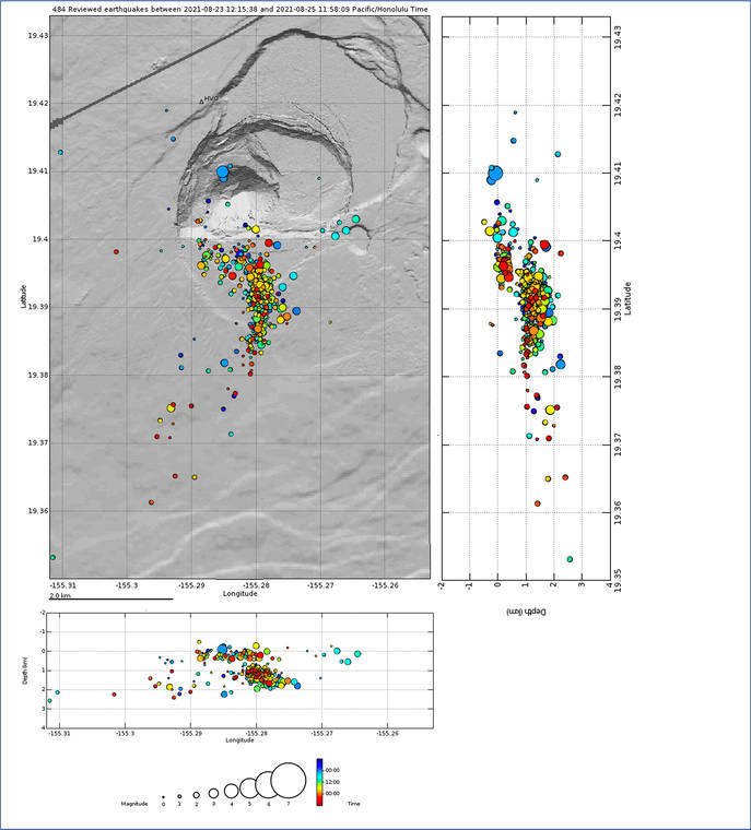
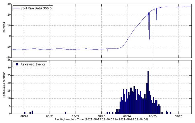
Late Monday afternoon, earthquake activity picked up at Kilauea’s summit. At about 1:30 a.m. HST on Tuesday, that activity intensified, and it became clear that seismicity and increasing deformation were indicating a new intrusion of magma. The seismicity extended southward from Halema‘uma‘u crater, to an area south of the Kilauea caldera.
An “intrusion” occurs when magma is injected into rocks underground, and new intrusions can be the first indication of a potential eruption. Because seismicity indicated the intrusion was within 0.6 to 1.2 miles of the surface, the USGS Hawaiian Volcano Observatory (HVO) increased Kilauea’s Volcano Alert Level and Aviation Color Code from Advisory/Yellow to Watch/Orange at 5:34 a.m. on Tuesday.
Heightened rates of seismicity occurred throughout the day on Tuesday, and summit tiltmeters showed ground motions consistent with continued growth of the intrusion. Seismicity and deformation activity peaked on Tuesday evening; then, both decreased considerably, and the intrusion appeared to have halted.
In seeking to understand current events, volcanologists often look to the past. We look for “analog” events that are similar to what is happening and that will give us a sense for what the future might hold. A very close analog event for this week’s activity was an intrusion in 2015.
The 2015 sequence of events started with inflation of the shallow Halema‘uma‘u magma reservoir, which triggered the overflow of Kilauea’s summit lava lake onto the floor of the crater. Seismicity then migrated south to the same area that has been active during the past few days. The episode last for about four days and also ended with an intrusion in an area south of the modern caldera outline.
These two south caldera intrusions (2015 and 2021) have strikingly similar patterns of seismicity and deformation, even though the 2015 event started quite differently. The patterns of seismicity and deformation suggest that the location and orientation of the intrusions are also quite similar.
Regional uplift patterns observed by satellite confirm that the center of the intrusive activity in both cases is well to the south of the caldera boundary faults. A third similar event was also recorded in 2006, prior to the formation of the lava lake within Halema‘uma‘u.
This area is well known for being the beginning of the path that magma follows to the lower regions of the Southwest Rift Zone of Kilauea. Earthquakes have been used to track the progress of magma intrusions through this pathway and HVO scientists call this “the seismic Southwest Rift Zone.”
Magmatic intrusions followed this pathway in the 1960s, 1970s, and early 1980s, but only one of these events led to an eruption. In December 1974, an intrusion began following this path southward, but erupted as a series of short fissure segments with a total length of 3 miles as it turned southwest.
The caldera collapse events in 2018 radically changed the surface landscape of Kilauea’s summit. However, it was unclear how much of the sub-surface magma storage and plumbing might have been changed. The fact that magma is being intruded and stored close to the caldera shows that some of the magmatic connections remain unchanged by the 2018 collapse.
The similarities of the 2015 and 2021 intrusions suggest that at least some of the summit connections are still in place. This is yet another line of evidence that while our view of Kilauea’s surface is entirely new, the volcano is not as much changed underground.
The magma storage system beneath Kilauea’s summit has clearly been refilling and inflating as it recovers from the 2018 eruption. Events like the recent summit eruption and this intrusion are the expected signs that the system is repressurizing due to continued input of magma. We expect to see continued intrusive activity and possible eruptive activity near the summit as magma reconnects with old pathways and storage regions.
On Thursday morning, the Volcano Alert Level and Aviation Color Code for Kilauea was changed again from Watch/Orange, back down to Advisory/Yellow as seismic activity and deformation had returned to pre-intrusive levels within the region. However, at the time of this writing Thursday evening, seismic activity and ground deformation had resumed in Kilauea’s south caldera region. Perhaps, this is only the first chapter in a much longer story!
Volcano Activity Updates
Kilauea is not erupting. Its USGS Volcano Alert level. Kilauea updates are issued weekly.
Earthquake activity and ground deformation levels have decreased in the area beneath the southern part of Kilauea’s summit caldera within the closed area of Hawaii Volcanoes National Park. However, summit GPS instruments continue to show gradual summit inflation over the past several months. Summit sulfur dioxide (SO2) emission rates remain at very low levels. For more information on current monitoring of Kilauea, see https://www.usgs.gov/volcanoes/kilauea/monitoring.
Mauna Loa is not erupting and remains at Volcano Alert Level ADVISORY. This alert level does not mean that an eruption is imminent or that progression to an eruption from the current level of unrest is certain. Mauna Loa updates are issued weekly.
This past week, about 43 small-magnitude earthquakes were recorded below the summit and upper elevation flanks of Mauna Loa. GPS measurements show low rates of deformation in the summit region over the past week. For more information on Mauna Loa, see: https://www.usgs.gov/volcanoes/mauna-loa/monitoring.
There were two events with three or more felt reports in the Hawaiian Islands during the past week: a magnitude-2.8 earthquake 13 miles west-northwest of Mountain View on Aug. 25 at 9:25 a.m. and a magnitude-3.3 earthquake 5 miles east-northeast of of Pahala on Aug. 20 at 10:16 a.m.
Visit https://www.usgs.gov/observatories/hawaiian-volcano-observatory for past Volcano Watch articles, Kilauea and Mauna Loa updates, volcano photos, maps, recent earthquake info, and more. Email questions to askHVO@usgs.gov.Volcano Watch is a weekly article and activity update written by USGS Hawaiian Volcano Observatory scientists and affiliates.


