Hurricane Douglas now a Category 4 storm

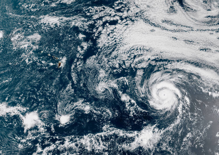
Hurricane Douglas strengthened overnight to a Category 3 storm as it continued its march toward the Hawaiian Islands. Credit: NOAA GOES-17

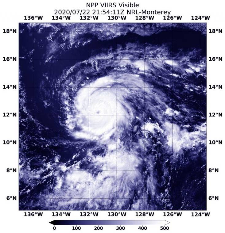
NASA-NOAA’s Suomi NPP satellite provided forecasters with a visible image of Hurricane Douglas at 5:54 p.m. EDT (2154 UTC) as it moved through the Eastern Pacific Ocean. Credit: NASA/NRL
Hurricane Douglas strengthened to a Category 4 storm as the tropical cyclone neared the Central Pacific Thursday evening.
Hurricane Douglas strengthened to a Category 4 storm as the tropical cyclone neared the Central Pacific Thursday evening.
Forecasters expect the storm to move near or over portions of the Hawaiian Islands this weekend, bringing the threat of strong winds, heavy rainfall and dangerous surf starting Sunday. Watches could be issued as early as Friday.
As of 5 p.m. Thursday, Douglas featured 130 mph winds and was tracking west-northwest at 18 mph approximately 1,125 miles east-southeast of Hilo, according to the National Hurricane Center in Miami, which will monitor the storm until it crosses 140 degrees west longitude, at which time the Central Pacific Hurricane Center in Honolulu will assume the role.
Hurricane-force winds currently extend outward from the center of the storm up to 30 miles while tropical-storm force winds reach outward up to 90 miles.
Little additional strengthening was expected Thursday before the storm is forecast to start weakening as it encounters cooler waters Friday. The storm is forecast to be near hurricane strength at approaches the state Saturday.
“Douglas is expected to move near or over portions of the Hawaiian Islands this weekend, and there is an increasing chance that strong winds, dangerous surf, and heavy rainfall could affect portions of the state beginning on Sunday. Interests on the Hawaiian Islands should continue to monitor the progress of Douglas and the official forecasts as they evolve over the next few days,” forecasters said.
Previous updates:
Hurricane Douglas continues to strengthen Thursday as the currently Category 3 storm nears the Central Pacific.
Forecasters expect the storm to move near or over portions of the Hawaiian Islands this weekend, bringing the threat of strong winds, heavy rainfall and dangerous surf starting Sunday. Watches could be issued as early as Friday.
As of 11 a.m. Thursday, Douglas featured 125 mph winds and was tracking west-northwest at 18 mph approximately 1,235 miles east-southeast of Hilo, according to the National Hurricane Center in Miami, which will monitor the storm until it crosses 140 degrees west longitude, at which time the Central Pacific Hurricane Center in Honolulu will assume the role.
Hurricane-force winds currently extend outward from the center of the storm up to 30 miles while tropical-storm force winds reach outward up to 90 miles.
Little additional strengthening was expected Thursday before the storm is forecast to start weakening as it encounters cooler waters. Though Douglas is anticipated to encounter warmer waters as it approaches the Hawaiian Islands on Sunday, wind shear is expected to increase continuing to weaken the storm as it approaches the Big Island.
“Douglas is expected to move near or over portions of the Hawaiian Islands this weekend, and there is an increasing chance that strong winds, dangerous surf, and heavy rainfall could affect portions of the state beginning on Sunday. Interests on the Hawaiian Islands should continue to monitor the progress of Douglas and the official forecasts as they evolve over the next few days,” forecasters said.
By 11 a.m. Sunday, Douglas is expected to be a Category 1 hurricane located about 30 miles offshore of Hilo. The current forecast track has the entire Big Island within the “cone of uncertainty.”
The next advisory will be issued at 5 p.m. Thursday.
Hurricane Douglas strengthened overnight to a Category 3 storm as it continued its march toward the Hawaiian Islands.
As of 5 a.m. Thursday, Douglas featured 120 mph winds and was tracking west-northwest at 20 mph approximately 1,335 miles east-southeast of Hilo, according to the National Hurricane Center in Miami, which will monitor the storm until it crosses 140 degrees west longitude, at which time the Central Pacific Hurricane Center in Honolulu will assume the role.
Hurricane-force winds currently extend outward from the center of the storm up to 30 miles while tropical-storm force winds reach outward up to 90 miles.
Additional strengthening is possible Thursday before the storm is expected to start weakening as it encounters cooler waters. Though Douglas is anticipated to encounter warmer waters as it approaches the Hawaiian Islands on Sunday, wind shear is expected to increase continuing weakening as the storm approaches.
“Douglas is expected to move near or over portions of the Hawaiian Islands this weekend, and there is an increasing chance that strong winds, dangerous surf, and heavy rainfall could affect portions of the state beginning on Sunday. Interests on the Hawaiian Islands should continue to monitor the progress of Douglas and the official forecasts as they evolve over the next few days,” forecasters said.
By 5 a.m. Sunday, Douglas is expected to be a Category 1 hurricane located about 100 miles offshore of Hilo. The current forecast track has the entire Big Island within the “cone of uncertainty.”
By 5 a.m. Monday, the cyclone’s expected to be downgraded to a tropical storm and be located south of Oahu.
The next advisory will be issued at 11 a.m.


