KAILUA-KONA — Big Islanders could begin to feel the effects of Hurricane Olivia as early as Tuesday night, forecasters with the Central Pacific Hurricane Center said Monday evening.
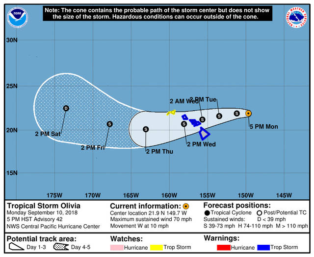
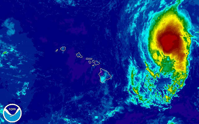
As of 5 p.m. Monday, Olivia was circulating 70 mph winds as it tracked west at 10 mph some 380 miles east-northeast of Hilo, according to forecasters with the Honolulu-based Central Pacific Hurricane Center.
A tropical storm warning remains in effect for Hawaii and Maui counties. The warning means that tropical storm conditions are expected somewhere within the warning area within 36 hours.
A high surf warning is also in effect for east-facing shores of the Hawaiian Islands through 6 p.m. Wednesday. Wave heights of 5 to 8 feet are forecast Monday. Surf is expected to build 10 to 14 feet Tuesday and then rise to 12 to 20 feet Tuesday night.
The storm’s expected to continue tracking west to west-southwest and gradually weaken over the next few days. On the current forecast track, the center of Olivia will be moving over the state as a tropical storm Tuesday night into Wednesday.
Damaging tropical storm-force winds may begin as early as Tuesday afternoon across Maui and the Big Island.
“It is important to remember that the mountainous terrain of Hawaii can produce localized areas of highly enhanced winds, even well away from the tropical cyclone center,” forecasters said.
The chance for flooding rainfall will increase rapidly late Tuesday and will remain a significant threat through at least Wednesday. Preliminary storm total rainfall amounts are in the 10- to 15-inch range, with isolated areas receiving up to 20 inches. Windward areas are forecast to see the most rainfall.
Also Monday, the state Department of Land and Natural Resources announced the closure at noon Tuesday of all Division of Forestry and Wildlife lands on the Big Island and in Maui County. Those lands include all forest reserves, natural area reserves, game management areas, wildlife sanctuaries, public hunting areas and Na Ala Hele trails.
The department will also close all state parks in East Hawaii at noon Tuesday. Closure of west-side parks will be evaluated as the storm approaches.
The closures remain in effect until further notice pending impact assessments.
All state small boat harbors, operated by the DLNR Division of Boating and Ocean Recreation, will remain open during the storm.
Behind Olivia in the Eastern Pacific, Tropical Depression Paul is expected to continue weakening and degenerate into a remnant low in a couple of days, Miami-based forecasters with the National Hurricane Center said Monday evening.
The storm had 35 mph winds as it churned west-northwest at 9 mph some 2,100 miles east of the Big Island as of 5 p.m. Monday. By Wednesday evening, Paul’s expected to be a remnant low packing 30 mph winds far east of the Hawaiian Islands.
Elsewhere in the Eastern Pacific, no tropical cyclone formation is forecast through Friday.
PRIOR COVERAGE:
KAILUA-KONA — Olivia weakened to a tropical storm Monday afternoon as the cyclone continues to move toward the Hawaiian Islands.
As of 2 p.m. Monday, the center of Olivia was located 415 miles east-northeast of Hilo and tracking west at 9 mph. It was circulating 70 mph winds with higher gusts.
A tropical storm warning remains in effect for Hawaii and Maui counties. The warning means that tropical storm conditions are expected somewhere within the warning area within 36 hours.
A high surf advisory is also in effect for east-facing shores of the Hawaiian Islands through 6 p.m. Wednesday. Wave heights of 5 to 8 feet are forecast Monday. Surf is expected to build 10 to 14 feet Tuesday and then rise to 12 to 20 feet Tuesday night.
The storm’s expected to continue tracking west to west-southwest and gradually weaken over the next few days. On the current forecast track, the center of Olivia will be moving over the state as a strong tropical storm Tuesday night into Wednesday.
Damaging tropical storm-force winds may begin as early as Tuesday afternoon across Maui and the Big Island. Hurricane-force wind gusts are possible as Olivia moves across the state Tuesday night and Wednesday.
The chance for flooding rainfall will increase rapidly late Tuesday and will remain a significant threat through at least Wednesday. Preliminary storm total rainfall amounts are in the 10- to 15-inch range, with isolated areas receiving up to 20 inches. Windward areas are forecast to see the most rainfall.
Also Monday, the state Department of Land and Natural Resources announced the closure at noon Tuesday of all Division of Forestry and Wildlife lands on the Big Island and in Maui County. Those lands include all forest reserves, natural area reserves, game management areas, wildlife sanctuaries, public hunting areas and Na Ala Hele trails.
The department will also close all state parks in East Hawaii at noon Tuesday. Closure of west-side parks will be evaluated as the storm approaches.
The closures remain in effect until further notice pending impact assessments.
All state small boat harbors, operated by the DLNR Division of Boating and Ocean Recreation, will remain open during the storm.
Behind Olivia in the Eastern Pacific, Tropical Storm Paul is expected to continue weakening Monday, and forecasters expect to downgrade the storm to a tropical depression Monday night.
The storm had 40 mph winds as it churned northwest at 10 mph some 2,185 miles east of the Big Island. By Thursday, Paul’s expected to be a remnant low packing 30 mph winds far east of the Hawaiian Islands.
Elsewhere in the Eastern Pacific, no tropical cyclone formation is forecast through Friday.
^
KAILUA-KONA — Big Islanders could begin to feel the effects of Hurricane Olivia as early as Tuesday night, forecasters with the Central Pacific Hurricane Center said Monday morning.
As of 11 a.m. Monday, the center of Hurricane Olivia was located 435 miles east-northeast of Hilo and tracking west near 9 mph. It was circulating 75 mph winds with higher gusts.
A continued west to west-southwest motion is expected for the next few days. Little change in intensity is expected Monday, with gradual weakening expected afterward, forecasters said.
A tropical storm warning remains in effect for Hawaii and Maui counties. The warning means that tropical storm conditions are expected somewhere within the warning area within 36 hours.
On the forecast track, the center of Olivia will be moving over the main Hawaiian Islands as a strong tropical storm Tuesday night into Wednesday.
Damaging tropical storm-force winds may begin as early as Tuesday afternoon across Maui and the Big Island. Hurricane-force wind gusts are possible as Olivia moves across the state Tuesday night and Wednesday.
The chance for flooding rainfall will increase rapidly late Tuesday and will remain a significant threat through at least Wednesday. Preliminary storm total rainfall amounts are in the 10- to 15-inch range, with isolated areas receiving up to 20 inches.
“Much of this rainfall will be focused on windward areas, many of which already received substantial amounts of rain from recent Hurricane Lane. However, flooding will be a significant threat for all areas,” forecasters cautioned.
A high surf advisory is also in effect for east-facing shores of the Hawaiian Islands through 6 p.m. Wednesday. Wave heights of 5 to 8 feet are forecast Monday. Surf is expected to build 10 to 14 feet Tuesday and then rise to 12 to 20 feet Tuesday night.
^
KAILUA-KONA — A tropical storm warning has been issued for Hawaii County as Hurricane Olivia continues march toward state.
As of 8 a.m. Monday, Hurricane Olivia featured 85 mph winds about 475 miles east of Hilo. It was tracking west at 8 mph, according to the Central Pacific Hurricane Center in Honolulu.
A tropical storm warning means that tropical storm conditions are expected somewhere within the warning area within 36 hours.
The warning is also is effect for Maui County. A tropical storm watch is in effect for Oahu.
A turn toward the west-southwest is expected starting later today, and this motion is expected to continue through Wednesday. On the forecast track, the center of Olivia will be moving over the main Hawaiian Islands Tuesday night into Wednesday.
Little change in strength is forecast today, with slight weakening starting tonight and continuing through Tuesday. However, Olivia is forecast to be a strong tropical storm when it reaches the Hawaiian Islands.
Forecasters said that Olivia is expected to produce total rainfall accumulations of 10 to 15 inches. Isolated maximum amounts of 20 inches are possible, especially over windward sections of Maui County and the Big Island. This rainfall may produce life-threatening flash flooding.
Large swells generated by Olivia will spread from east to west across the Hawaiian Islands early this week. This will cause surf to build along exposed east facing shorelines as Olivia approaches, forecasters cautioned.


