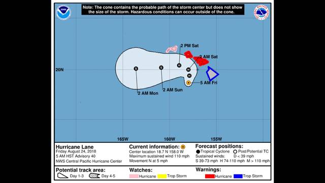
KAILUA-KONA — Tropical storm conditions and hurricane conditions continue to be a possibility today and tonight as Hurricane Lane churns its way toward the islands. The now-category 2 storm is expected to pass close to the main islands today, still as a hurricane, bringing damaging winds, according to the National Weather Service.
By late Thursday afternoon, Hurricane Lane had already dropped more than 2 feet of rain on a couple spots in windward Hawaii Island.
While West Hawaii didn’t see such torrential rainfall as that — the National Weather Service said less than a quarter inch of rain fell at the Ellison Onizuka Kona International Airport at Keahole — forecasters warned of dangerous sea conditions created by high surge and surf that began hitting the Kona coast Thursday. Large swells created by the storm are expected to have a severe impact on the islands over the coming days and will lead to “very large and damaging surf” along west and south coasts.
As of 8 a.m. Thursday, the storm’s center was approximately 140 miles west-southwest of Kailua-Kona with maximum sustained winds of 105 mph. The storm was moving north at 5 mph, forecasters said.
A tropical storm warning remains in effect for Hawaii County. A hurricane warning remained in effect for Oahu and Maui, while Kauai was under a hurricane watch.
During a press conference in Oahu, forecaster Leigh Anne Eaton of the National Weather Service said Hurricane Lane was likely to continue moving north “pretty slowly” for another 24-36 hours before making a turn to the west.
Eaton said Hurricane Lane “has already started to show signs of weakening,” noting the storm at that time had been downgraded from a category 4 hurricane after maximum sustained winds fell to 125 mph. The storm was also anticipated to move into higher shear, effectively weakening the storm further.
“It is still expected to pass dangerously close to the islands as a hurricane on Friday,” she said.
Lane’s center was expected to move “over, or dangerously close to” parts of the main islands today, according to the 5 p.m. update from the National Weather Service. Its turn to the west is expected Saturday and Sunday, accompanied by an increase in forward speed.
Gov. David Ige, also speaking at the press conference, urged residents across the state to stay informed.
“Hurricane Lane is still a dangerous and powerful storm,” he said, “and so we are asking all of our residents statewide to pay attention, listen to the updates and the forecasts.”
By that time, Lane had already dropped torrential rain over parts of Hawaii Island, mostly on the eastern side.
Forecasters said the storm’s slow movement raises the threat for prolonged heavy rains and high rainfall totals, which could lead to major, life-threatening flash flooding and landslides on all islands.
Eaton said forecasters had measured nearly 15 inches of rain near the Hilo International Airport and 18 inches of rain in Hakalau.
She added rains were expected to continue for another 36-48 hours “pretty much across the state.”
But it’s not just the torrential rainfall forecasters are watching. Hurricane Lane also brought high surf to the island’s southwest coasts, including surf heights of 10-15 feet along the Kona coast.
A combination of storm surge and large waves, the National Weather Service added, could also increase water levels by 2-4 feet above normal levels along south and west shores near the storm’s center.


Kona skated
too bad that the sort sighted Government doesn’t build hydro electric dams to fix our energy problems,but HELCO wouldn’t like bringing down the cost of electricity,but imagine all those millions of gallons of water just flowing in the ocean being put to good use–food for thought