KAILUA-KONA — Hurricane Fernanda is expected to enter the Central Pacific as a tropical storm on Thursday as the cyclone continues its march toward the Hawaiian Islands. ADVERTISING KAILUA-KONA — Hurricane Fernanda is expected to enter the Central Pacific as
KAILUA-KONA — Hurricane Fernanda is expected to enter the Central Pacific as a tropical storm on Thursday as the cyclone continues its march toward the Hawaiian Islands.
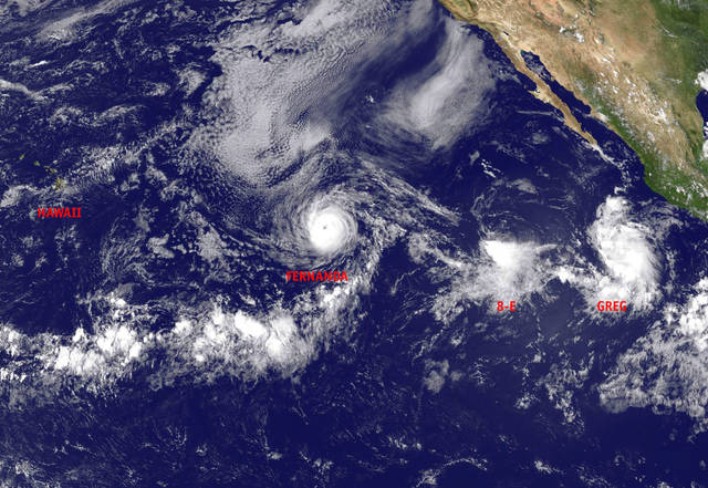
And behind Fernanda are two other systems being monitored in the Eastern Pacific.
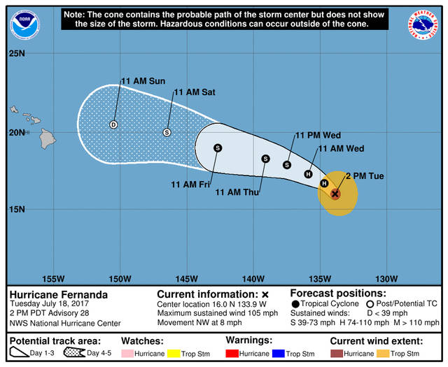
As of Tuesday afternoon, Fernanda was a Category 2 hurricane packing 105 mph winds located about 1,415 miles east of Hilo. It’s expected to continue tracking west-northwest around 8-9 mph for the next couple of days, forecasters with the National Hurricane Center in Miami said.
Continued gradual weakening is forecast during the next 48 hours, and Fernanda is expected to become a tropical storm by Thursday.
It’s forecast to enter the Central Pacific basin, which is where Hawaii is located, sometime Thursday still categorized as a tropical storm. As of Thursday afternoon, Fernanda, shortly before reaching the basin, will be about 1,000 miles east-southeast of Hilo and packing 60 mph winds.
And, by Sunday Fernanda will likely be downgraded to a remnant low just about 300 miles east-northeast of the Big Island.
Forecasters said there are indications that a significant slug of moisture associated with the remnants may move near/over the islands, however, that will depend on the storm’s actual track. A long period east swell from Fernanda is forecast to build this week.
Behind the weakening Fernanda is Tropical Storm Greg, which was located about 435 miles southwest of Manzanillo, Mexico, as of Tuesday afternoon. Maximum sustained winds were around 40 mph and additional strengthening is forecast as the storm moves over warmer water during the next couple of days.
Greg is forecast to continue tracking west-northwest, however, it could interact with newly formed Tropical Depression 8-E forcing Greg to turn more toward the west. Based on current forecast models, Tropical Storm Greg is forecast to peak at 60 mph early Thursday before losing steam. By early next week, Greg should be a remnant low more than 1,700 miles east of the Big Island.
Tropical Depression 8-E featured maximum sustained winds of 35 mph and little strengthening is forecast.


