If something is hot enough, it emits light in wavelengths that are visible to the human eye. This is called incandescence. If you’ve ever seen the red-, orange-, or yellow-ish glow from Kilauea Volcano’s lava lake or an active lava
If something is hot enough, it emits light in wavelengths that are visible to the human eye. This is called incandescence. If you’ve ever seen the red-, orange-, or yellow-ish glow from Kilauea Volcano’s lava lake or an active lava flow, then you have observed incandescence.
Color is a rough indication of the temperature of hot materials, including lava. The human eye is remarkably sensitive to subtle color differences, and, with some practice, you can roughly estimate the temperature range of an object based on the color of its incandescent glow.
For example, yellow indicates a temperature of about 1,832-2,192 degrees. Orange indicates a slightly cooler temperature of about 1,472-1,832 degrees, while red is even cooler, about 1,112-1,472 degrees.
A remote sensing instrument that can determine the temperature of distant objects based on their incandescent color is called an optical pyrometer. “Remote sensing” refers to the use of imaging technology that acts as extensions of our eyes, allowing us to see the world in a new light and from different perspectives.
One of the most important characteristics of active lava is its eruption temperature. This information can help determine the lava’s composition and flow characteristics. It also provides important hints about the magma’s plumbing system, source region, and supply rate, and how far the lava might travel.
The outer surface of erupting lava cools incredibly quickly when it is first exposed to air — hundreds of degrees per second. Hence, remotely measuring the eruption temperature is an attempt to record something that is visible for only a fraction of a second. Previous work on Kilauea and other active volcanoes has demonstrated that existing methods of remotely determining lava flow temperatures can have hundreds of degrees of uncertainty.
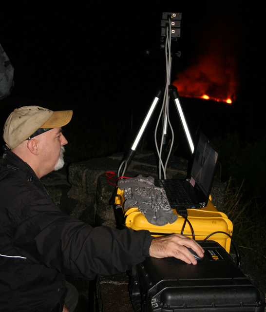
In early December 2016, scientists from the U.S. Geological Survey and NASA visited Kilauea Volcano to experiment with a portable, ground-based camera system for use as an optical imaging pyrometer. The custom-built, high-speed camera can acquire images at more than 50 frames per second in three wavelengths (green, red, and near-infrared). It was calibrated by collecting images of a high-temperature calibration oven.
During their field work, the USGS and NASA scientists collected thousands of images of active lava from Kilauea’s two ongoing eruptions. This included breakouts along the 61g lava flow, as well as spattering lava along the edges of the summit lava lake, which was visible from the Jaggar Museum overlook in Hawaii Volcanoes National Park.
The eruption temperature of Kilauea lava is well-known — up to about 2,140 degrees at the summit and around 2,084 degrees on the East Rift Zone. Because of this, the volcano is the perfect place to determine how these camera data can be used to retrieve reliable temperatures from the hottest parts of active flows and lava lakes.
The results of this study will establish the validity of a generic data processing method that could be applied to other satellite, airborne, and ground-based remote sensing data sets. The ultimate goal of this NASA-funded research is to design an instrument capable of reliably measuring the temperature of active lava on Jupiter’s moon, Io, the only other object in our solar system known to have active, high-temperature volcanism.
Kilauea Volcano is one of the best places in the world for scientists to conduct their remote sensing research, which is important for future NASA missions to the outer reaches of our solar system.
Volcano Watch is a weekly article and activity update written by U.S. Geological Survey Hawaiian Volcano Observatory scientists and colleagues.
Volcano Activity Updates
Kilauea continues to erupt at its summit and East Rift Zone. This past week, the summit lava lake level varied between about 66-98 feet below the vent rim. The 61g flow was still active, with lava entering the ocean near Kamokuna and surface breakouts downslope of Puu Oo and on the coastal plain about 0.5 miles inland of the ocean. The 61g flows do not pose an immediate threat to nearby communities.
Mauna Loa is not erupting. During the past week, a few dozen small-magnitude earthquakes occurred beneath the volcano, primarily in the upper Southwest Rift at depths less than 3 miles, with a few on the volcano’s west flank at slightly greater depths. GPS measurements continue to show deformation related to inflation of a magma reservoir beneath the summit and upper Southwest Rift Zone. No significant change in the summit fumarole temperature was noted this past week.
Two earthquakes were reported felt on Hawaii Island this past week. At 5:33 a.m. on Feb. 17, a magnitude-4.6 earthquake occurred 14.7 miles northwest of Kawaihae at a depth of 25 miles, and, at 5:49 a.m., a magnitude-2.4 earthquake occurred 13.9 miles northwest of Kawaihae at a depth of 24 miles.
Visit https://hvo.wr.usgs.gov for past Volcano Watch articles, Kilauea daily eruption updates, Mauna Loa weekly updates, volcano photos, recent earthquakes info, and more; call for summary updates at 808-967-8862 (Kilauea) or 808-967-8866 (Mauna Loa); email questions to askHVO@usgs.gov.


