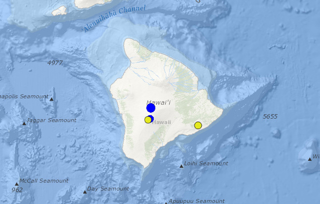
Two earthquakes with magnitudes greater than 3.0 were recorded early Monday in the vicinity of the Mauna Loa summit. ADVERTISING Two earthquakes with magnitudes greater than 3.0 were recorded early Monday in the vicinity of the Mauna Loa summit. The
Two earthquakes with magnitudes greater than 3.0 were recorded early Monday in the vicinity of the Mauna Loa summit.
The first temblor, a magnitude-3.9, struck at 1:52 a.m. about 4.1 miles north-northeast of the Mauna Loa summit. It had a registered depth of 7.5 miles, according to the U.S. Geological Survey. Eleven people reported feeling the earthquake; most of the reports were made by those in the Captain Cook area.
The second, a magnitude-3.0, was recorded at 4:01 a.m. about 3.8 miles south-southwest of the Mauna Loa summit. It had a registered depth of 1.5 miles. Just three people reported feeling the earthquake; two were in Captain Cook and one was in Kailua-Kona.
Neither earthquake prompted an advisory from the Pacific Tsunami Warning Center in Honolulu.
Since Sept. 17, when scientists at the observatory upped the Volcano Alert Level for Mauna Loa from “normal” to “advisory,” elevated seismicity within the volcano and deformation across its flanks persist, according to the U.S. Geological Survey Hawaiian Volcano Observatory.
In the past week, earthquakes have been occurring mostly beneath the volcano’s upper Southwest Rift Zone at depths less than 3 miles, scientists said. The magnitude-3.0 temblor that struck Monday was located in this region, while the first earthquake was located on the north side of the volcano.
GPS measurements continue to show deformation related to inflation of a magma reservoir complex beneath the summit and upper Southwest Rift Zone. During inflation, magma rises into the summit reservoir; the summit reservoir enters the deflation portion of the cycle when the magma moves laterally into a rift zone and either erupts or is stored there.


