The Big Island’s dengue fever outbreak reached 92 cases on Monday, matching the number confirmed on Maui during the 2001 outbreak. ADVERTISING The Big Island’s dengue fever outbreak reached 92 cases on Monday, matching the number confirmed on Maui during
The Big Island’s dengue fever outbreak reached 92 cases on Monday, matching the number confirmed on Maui during the 2001 outbreak.
Since the state began its response to the outbreak in late October, health officials have often repeated the phrase “every outbreak is different.” And the growth in Hawaii Island cases has shown that to be true, reaching in a little over two months the same number of cases that sickened people over the course of five months on Maui.
“I think there’s definitely some differences between the Maui outbreak and this outbreak,” said Darryl Oliveira, administrator of Hawaii County Civil Defense, the lead agency in the response to the mosquito-borne disease.
“In Maui, we didn’t have that migration element. It was more contained to that one particular location (in Hana),” he said.
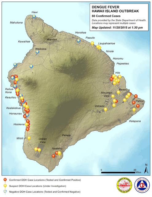
As the release of a new map showed last week, the dengue fever outbreak has spread to both sides of the Big Island, with confirmed cases popping up all along the Kona Coast from Kailua-Kona to below Hookena, as well as Naalehu, Pahoa, Keaau, Fern Acres and Hilo.
Health officials have explained that the species of mosquitoes capable of transmitting dengue do not stray further than 200 yards from their homes, so the spread of the disease has been caused by the movement across island of human beings, Oliveira said.
However, he said, the increases in the numbers of cases still remain at relatively low levels, according to graphs provided by the Department of Health.
“The DOH’s (epidemiologic) curve shows that it’s not a real rapid climb,” Oliveira said. “It’s a pretty steady trickle. And (today) we only had four additional cases, so we may not be seeing a rapid climb. We are definitely concerned, though, and watching it.”
Officials hope that as they continue their “Fight the Bite!” campaign, the new cases of dengue will begin to drop off as isle residents learn how to best prevent themselves from being bitten by mosquitoes, thus cutting off the only way to spread the disease.
The release on Friday afternoon of the new Civil Defense map also shows that officials are taking a different approach to the public than they did at the beginning of the outbreak.
Early on, health officials said they did not want to release more information than absolutely necessary about the locations where cases of dengue had been found. Instead, they highlighted a few general areas around the island. That response has now evolved, Oliveira said.
“We’re all working together on this, and there can always be different views that come out,” he said. “Our experience (at Civil Defense) has been, over the many events we’ve worked with, be it (Tropical Storm) Iselle or the lava flow, is that we’d like to provide as much information to the community, so they can have a better understanding of what we’re talking about.”
Oliveira explained that early on, there was some concern that if people saw they did not live in an area where cases had been discovered, they would become complacent in their response and fail to safeguard their homes and workplaces from mosquitoes.
“After some discussion, we decided it was unlikely that we would see complacency,” he said. “As you saw, the map depicts an islandwide concern, and we think people would see that.”
For more information on the outbreak, visit https://health.hawaii.gov/docd/dengue-outbreak-2015/.
For periodic updates from Hawaii County Civil Defense, visit www.hawaiicounty.gov/active-alerts/.
Email Colin M. Stewart at cstewart@hawaiitribune-herald.com.


