Hurricane Olaf weakened to a Category 2 storm Thursday morning as it headed north-northwest well east of the Big Island. ADVERTISING Hurricane Olaf weakened to a Category 2 storm Thursday morning as it headed north-northwest well east of the Big
Hurricane Olaf weakened to a Category 2 storm Thursday morning as it headed north-northwest well east of the Big Island.
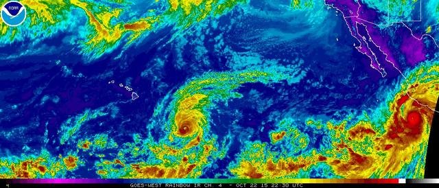
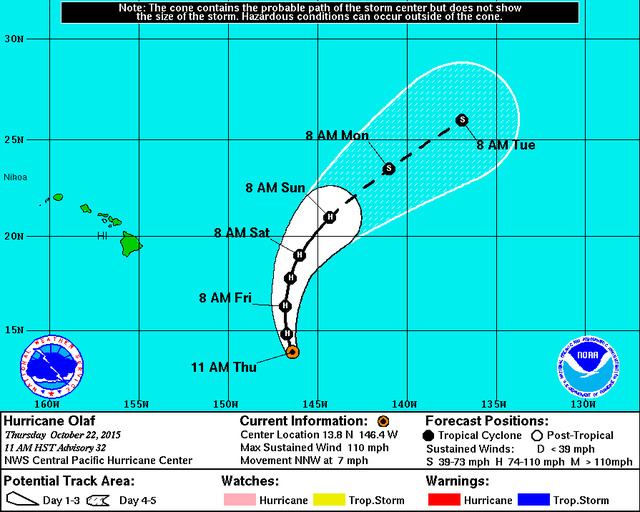
Located 705 miles southeast of the Big Island, Olaf had maximum sustained winds of 110 mph winds and heading north-northwest at 7 mph as of 11 a.m. Thursday, the Central Pacific Hurricane Center said. Tropical storm-force winds extended 155 miles and hurricane-force winds 30 miles from the storm’s center.
Olaf is expected to continue heading north-northwest Thursday before turning toward the north and becoming embedded this weekend within mid-latitude westerlies that will steer the storm northeast and farther away from the state, forecasters said.
Weakening is expected to continue in the coming days as the former Category 4 hurricane moves over cooler water, forecasters said. Wind shear is also forecast to pick up soon which should help weaken the storm further.
By Friday morning, weather models have the hurricane weakened to a Category 2 storm with maximum sustained winds of 105 mph about 550 miles southeast of Hilo. Olaf should weaken to a tropical storm on Monday, at which time it will be located about 1,000 miles north-northeast of Hilo.
Though Olaf continues to move away from the islands, swells generated by the storm will impact east-facing shores through the weekend.
A high surf warning is in effect for northern, eastern and southern coasts through 6 p.m. Saturday. Wave heights of 12 to 18 feet are forecast. A high surf advisory is in effect for south-facing shores through 6 a.m. Saturday. Wave heights of 5 to 8 feet are expected along the Kona Coast.
Elsewhere in the Central Pacific, which is where Hawaii is located, no tropical cyclones were expected to develop through Saturday morning.
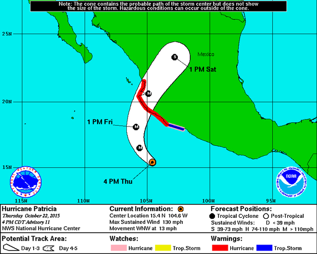
Closer to North America, Hurricane Patricia was located about 250 miles south of Manzanillo, Mexico, the National Hurricane Center said at 11 a.m. Thursday. Patricia, a Category 4 hurricane, was moving west-northwest at 13 mph and featured maximum sustained winds of 130 mph. Hurricane-force winds extended 30 miles from the storm’s center while tropical storm-force winds extended outward up to 175 miles.
Continued strengthening is forecast, and Patricia is expected to make landfall sometime Friday. Rapid weakening is then forecast as the storm moves inland.
“Patricia is expected to remain an extremely dangerous hurricane through landfall,” forecasters said, urging people to finish preparations for the storm’s arrival.
A hurricane warning has been posted for areas of the Mexico coast, from San Blas to Punta San Telmo; a hurricane watch is in effect for areas east of Punta San Telmo to Lazaro Cardenas. A tropical storm warning is in effect for areas east Punta San Telmo to Lazaro Cardenas.
Patricia could drench the Mexican states of Jalisco, Colima, Michoacan and Guerrero with up to a foot of rainfall through Saturday, forecasters said, cautioning of the threat of flash floods and mudslides.
The National Hurricane Center was also keeping tabs on an area of low pressure expected to develop several hundred miles off the southern tip of the Baja California peninsula later this week. It has just a 20 percent chance of developing into a tropical depression within five days.
Get more hurricane-related content, including preparation tips, evacuation info and daily tropical weather updates, on our hurricane season page, sponsored by Clark Realty, at www.westhawaiitoday.com/hurricane-season-2015.


