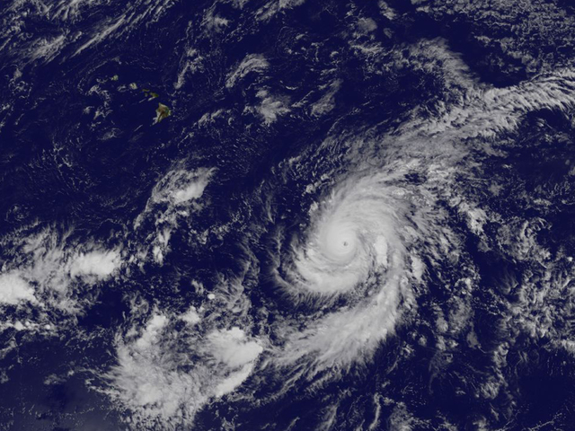
Forecasters with the Central Pacific Hurricane Center expect Hurricane Olaf to bring little impact to Hawaii Island besides pounding surf and the potential for enhanced trade winds and their showers. ADVERTISING Forecasters with the Central Pacific Hurricane Center expect Hurricane
Forecasters with the Central Pacific Hurricane Center expect Hurricane Olaf to bring little impact to Hawaii Island besides pounding surf and the potential for enhanced trade winds and their showers.
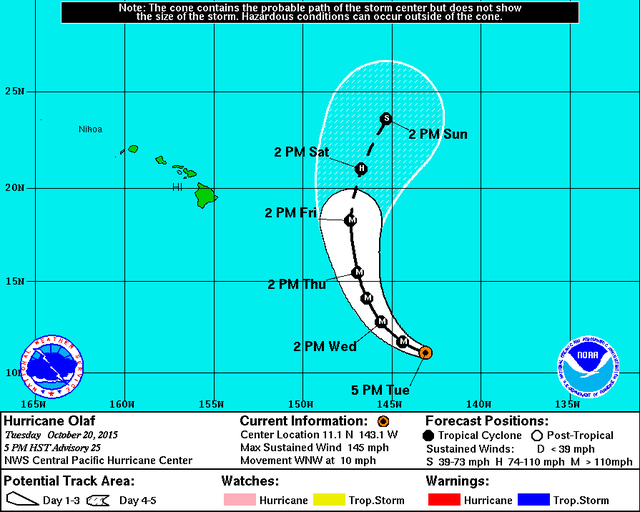
But they also caution there could be changes to the forecast track that will likely put the churning, 300-mile wide storm well east and then northeast of the island over the weekend.
“I wouldn’t want to get keyed into that track,” forecaster Pete Donaldson said. “The models are in good agreement but it’s far enough out, it could change.”
Located 995 miles southeast of the Big Island and peaking with 150 mph winds on Tuesday, Olaf was a Category 4 cyclone slowly making its way west-northwest at 10 mph through warm 84-degree waters. Hurricane force winds extended 40 miles from the center, and tropical storm force winds reached out 140 miles.
The storm was set to begin gradual weakening on Wednesday. A more northwesterly turn was expected to bring the system abreast the island but about 500 miles east on Saturday.
At that time, winds are forecast to have weakened into the 90 mph range due to increased shear and cooler sea temperatures. But Olaf is forecast to remain a major hurricane through Friday.
A moist environment and low shear combined with that ample warmth from the ocean were expected to keep the cyclone spinning around 150 to 155 mph on Wednesday, just below the threshold for a Category 5 system. The storm is the season’s record 15th tropical cyclone to make way in the Central North Pacific basin.
Donaldson said that precise effects are hard to predict until the track of the hurricane is more solid. Surf could begin to build Wednesday, leading to waves large enough to cause damage and life-threatening conditions along east and south shorelines. A high surf advisory was posted for east-facing shores through 6 a.m. Thursday. Wave heights are forecast to be between 6 and 10 feet along the island’s northern and eastern coasts.
Moisture along the edges of the the hurricane could bring rainfall mainly to the windward side of the island by Friday.
The good news is that Olaf will switch the winds out of the north rather than cutting off the trade winds the way multiple tropical systems did over the summer. That means the island will receive possibly brisk northerly flow rather than sticky, humid conditions.
Get more hurricane-related content, including preparation tips, evacuation info and daily tropical weather updates, on our hurricane season page, sponsored by Clark Realty, at www.westhawaiitoday.com/hurricane-season-2015.


