Last month saw more than high temperature records falling on Hawaii Island.
A multitude of hurricanes and tropical storms in the Central Pacific served to dump record-breaking amounts of water on the Big Island, according to National Weather Service hydrologist Kevin Kodama.
“We saw record-breaking wetness in several spots,” he said. “There were not as many records broken on the Big Island as the other various places in the state. But it was still wet, and if it didn’t break records, we had several sites that showed the wettest conditions in at least 10-20 years. It was scattered all over the place. Windward side, up north, Hamakua, Kamuela. Hilo Airport (had the) wettest August since 1991.”
Sites on the Big Isle that experienced record-breaking rainfall last month include Honaunau, with 10.34 inches, breaking the previous record of 8.2 inches set in 2004; Upolu Airport, registering 4.7 inches, besting the previous record of 3.99 inches set in 1995; Kamuela with 6.93 inches, beating 1991’s record rainfall of 6.61 inches; and Mountain View, which collected 23.58 inches of rain, beating a 1994 record of 21.92 inches.
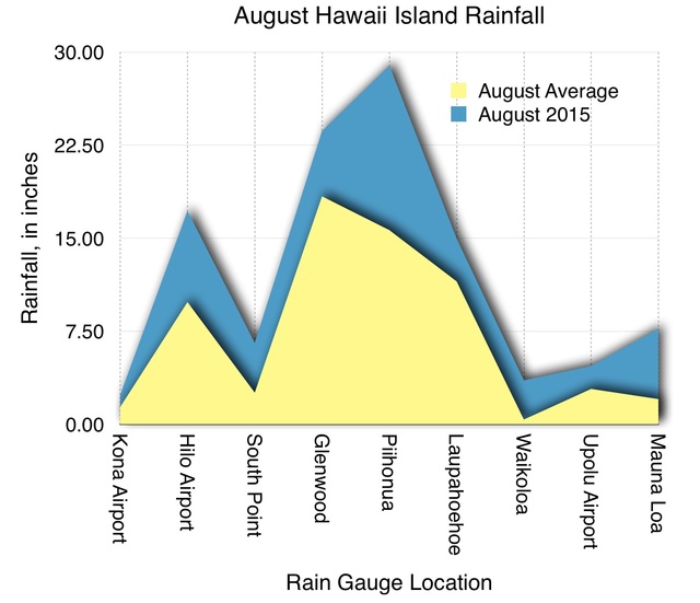
The rain gauge at the Hilo International Airport recorded 17.2 inches in August, which wasn’t a record, but did represent 175 percent of its average August rainfall of 9.85 inches. That wasn’t anywhere near the largest departure from normal rainfall levels.
Various rain gauges on the leeward side of the island exceeded their cumulative August rain totals many times over.
The normally very dry Waikoloa area saw cumulative rain last month of 3.54 inches, representing a 932 percent increase over the average .38 inches. Measurements taken at Pohakuloa Kipuka Alala totaled 10.24 inches, or 875 percent of the normal rainfall of 1.17 inches.
The most rain fell at the U.S. Geological Survey’s Saddle Quarry site, located along Saddle Road about 15 miles mauka of Hilo. That rain gauge logged 29.06 inches of rainfall in August, a 234 percent increase over the site’s average rainfall in August.
The only site on the island that didn’t see higher than average rainfall was the Nene Cabin site, located in Ka’u. Nene Cabin measured 7.30 inches, just shy of its average August total of 7.94 inches.
Kodama noted that the Big Island’s high rainfall totals largely were the result of just a few short periods of very heavy rainfall, rather than extended periods of rainfall.
“I think it’s mostly been coming in big bursts. The high totals are occurring over a smaller number of days during unstable conditions,” he said. “The whole pattern during August was very disrupted.”
Kodama predicted that when the island’s drought levels are recalculated next week, many areas that previously were categorized as being under moderate drought will return to normal.
It’s still too soon to tell what kind of an impact the rainfall will have on farmers and ranchers, but Kodama said he spoke with a rancher last week who said he had more grass on his pasture lands than his cattle could handle.
“Over the months and years he’s destocked a bunch, and now he’s got more grass than he can use,” Kodama said.
Now that the storm systems in the Pacific have died down, some areas on the Big Island are shaping up for a dry September. The Hilo gauge so far has measured only .07 inches of rain, considerably less than the average September total of 3.06.
However, high temperatures are continuing, with Hilo registering six record-setting days this month. And several of those records didn’t just beat the previous temperatures. They shattered them by as much as 4 degrees.
Sept. 1 saw a high of 92 degrees, breaking the previous record of 88 set in 2014. That was followed by a record high of 93 the next day, breaking a previous record of 89 set in 1987.
Sept. 4-7 all were record-setters as well, with the highest temperature of 91 degrees occurring on Sept. 6. That broke a previous record of 87 set in 2014.
Kodama said despite the return of Hawaii’s cooling trade winds, area residents can expect unusually high temps to continue for a while.
“We’ll get our trades back to some degree, but it’s not going to be as cool as it is normally,” he said. “The ocean temps are still going to be warm. … We’re talking weeks and months. It’s going to hang around for a while. It’s going to be warm and humid trades. At least we’ll have a breeze that will help, but it’s not like it’s going to be back to the good old days.”
———
September record-breaking heat
Sept. 1 – 92 degrees, breaking old record of 88 set in 2014.
Sept. 2 – 93 degrees, breaking old record of 89 set in 1987.
Sept. 4 – 89 degrees, breaking old record of 87 set in 1990.
Sept. 5 – 89 degrees, breaking old record of 88 set in 1995.
Sept. 6 – 91 degrees, breaking old record of 87 set in 2014
Sept. 7 – 90 degrees, tying record of 90 set in 1976.
Email Colin M. Stewart at cstewart@hawaiitribune-herald.com.


