Ignacio weakened to Category 3 hurricane with 115 mph wind on Sunday evening as strong wind shear began to gnaw at the system. Forecasters with the National Weather Service have continued to nudge the forecast track of the cyclone slightly
Ignacio weakened to Category 3 hurricane with 115 mph wind on Sunday evening as strong wind shear began to gnaw at the system. Forecasters with the National Weather Service have continued to nudge the forecast track of the cyclone slightly further north, away from the islands.
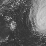
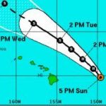
Satellite imagery Sunday showed the eye of Ignacio had become ragged and filled with clouds. The storm, located 355 miles east of Hilo, has made slight northward turn, but is expected to track slightly more westward over the next couple of days, taking the cyclone in a gradual arc to the northwest, with the center passing about 200 miles northeast of the island Monday evening with 80 mph winds. Forecasters say a rapid weakening could reduce the system to a tropical storm by Tuesday.
Hurricane force winds extended out 30 miles from the center and tropical storm force winds reached out 160 miles as Ignacio moved to the northwest at 12 mph. Rainfall of 1 to 4 inches and up to 5 inches in some areas is forecast, with the chance of tropical storm conditions on the Big Island at 12 percent.
Patches of heavy rainfall cropping up ahead of Ignacio were prompting a flood advisory through Sunday evening for the northern portion of the island from Kealakekua to Laupahoehoe.
A tropical storm warning for windward waters was in effect with potentially damaging wind and waves, and a hurricane warning has been issued for offshore waters. A tropical storm watch and high surf advisory for the Big Island continued, with dangerous 12 to 20-foot surf on east and south shores arriving Sunday and sticking around through Tuesday, and high potential for coastal flooding in low-lying areas.
As the Eastern and Central Pacific hosted a trio of major cyclones on Sunday, Hurricane Jimena’s winds fluctuated strength, registering 150 mph on Sunday evening. The massive system was 1,525 miles east of Hilo, and was traveling west-northwest at 15 mph. Forecasters with the National Hurricane Center in Florida expect gradual weakening, with the cyclone remaining a hurricane through Friday.
Forecasters are not yet able to quantify how much of a threat Jimena poses to Hawaii.
Hurricane Kilo was a Category 3 system with 125 mph wind about 570 miles south of Midway Island as it heads west-northwest at 9 mph.

Subscribe today for unlimited access.
Already a subscriber?
Login
Not ready to subscribe?
Register for limited access.
If you have a print subscription but require digital access,
activate your account.


