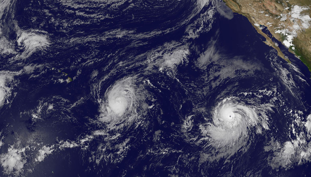
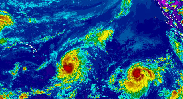
A cyclone-weary island and state are bracing for potential storm impacts as Hurricane Ignacio makes a path toward the islands — followed by another potent cyclone whose threat is still impossible to gauge.
The Red Cross has called up hundreds of volunteers ahead of the storms, positioning supplies and putting shelter workers and health and case workers on standby in the face of potential statewide impacts. Ignacio was a Category 1 hurricane with 90 mph winds Friday afternoon, located about 780 miles east-southeast of Hilo. Hurricane force winds extended 25 miles from the center and tropical storm force winds reached out 80 miles.
The official forecast track has the cyclone passing 100 miles north of the island as a Category 1 hurricane late Monday packing 90 mph winds.
All of the islands are within the cone of uncertainty and a small change in factors could bring the storm directly over the islands.
Tropical storm force winds could be felt by Sunday evening on the Big Island and high surf is expected to begin impacting east- and south-facing shores Saturday through Monday.
“The strength is significant enough that, even if it only passed close by, there would still be significant impacts,” said National Weather Service meteorologist Chris Brenchley.
Surf pushed ahead of Ignacio is set to peak with 15- to 20-foot faces Sunday night and Monday.
Rainfall amounts are still hard to predict, Brenchley said. However, “the threat is there for more heavy rain, and soils are already saturated from the past days of heavy downpours,” he said.
The weather models are in fairly good agreement on the track of Ignacio, Brenchley said. But it’s still possible the storm could swing further north than anticipated or even weaken more rapidly and slide south of the islands in a manner similar to Hurricane Hilda.
Ignacio is traveling northwest at 8 mph over an area of 83-degree water with weak shear. The favorable environment is expected to allow the cyclone to strengthen and peak at 105 mph on Sunday before gradually weakening as the water cools and southwest shear increases.
Far behind Ignacio, Hurricane Jimena continued to rapidly intensify in the Eastern Pacific Friday evening. At 1,200 miles southwest of the southern tip of Baja California, the cyclone was a Category 3 hurricane with 125 mph winds, traveling west at 12 mph, and was expected to peak near Category 5 with 150 mph winds on Saturday. Hurricane force winds extended outward 30 miles from the center and tropical storm force winds reached out 105 miles.
Ignacio and Jimena have the state’s emergency managers on notice, and Gov. David Ige issued an emergency proclamation Friday afternoon. The approach of the duo has echoes of hurricanes Iselle and Julio in 2014, and it happens to fall near the anniversary of Hurricane Katrina, which made landfall and devastated New Orleans 10 years ago on Saturday.
“We’re beginning preliminary work now to staff emergency shelters,” said Barney Sheffield, the Big Island’s disaster coordinator for the Red Cross. “The track is trending a little north right now but there are no guarantees.”
Hawaii County Civil Defense Chief Darryl Oliveira said the Fire Department will be flying back-country trails Saturday to warn campers of the situation. The state Department of Land and Natural Resources and the National Park Service are planning closures, and Civil Defense will be going door to door in Kapoho and other low-lying areas to warn residents of possible impacts, Oliveira said.
Emergency managers acknowledged an exhaustion factor as Ignacio marks the eighth tropical cyclone this season to make its way into the Central North Pacific basin.
“We understand the public is fatigued from experiencing four major approaching storms so far this season, but we urge people to take the weekend to prepare their homes and families for impacts that could be felt statewide,” said Doug Mayne, administrator of the Hawaii Emergency Management Agency, in a statement. “Severe weather associated with Ignacio is expected, and with Jimena not far behind, we need to ready ourselves and our loved ones as much as possible with the time we have.”
Oliveira said each event is unpredictable despite best efforts to forecast the cyclones’ movements.
“I think we all should prepare and do our part,” he said. “If we prepare and nothing happens, it’s a good thing.”


