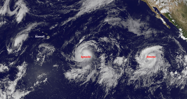
Hurricane Ignacio crossed into the Central Pacific Thursday and remains on a forecast track that brings the storm near the Big Island early next week. ADVERTISING Hurricane Ignacio crossed into the Central Pacific Thursday and remains on a forecast track
Hurricane Ignacio crossed into the Central Pacific Thursday and remains on a forecast track that brings the storm near the Big Island early next week.
Though the current forecast track has Ignacio tracking north of Hawaii County as a Category 1 storm early next week, the island remains within the cone of uncertainty that represents the probable track of the center of the storm. That track, which becomes more uncertain three to five days out, can deviate some 200 to 300 miles to the north or south, said Chevy Chevalier, a meteorologist with the National Weather Service in Honolulu.
“People should be prepared and vigilant of the forecast,” Chevalier said. “This is a very active season, El Nino is in place and with the relative lack of shear some of these storms maintain their strength and even strengthen as they move to the north (and near Hawaii). So, you’ve got to be prepared now.”
Located 975 miles east-southeast of the Big Island and tracking toward the west-northwest at 13 mph, Ignacio was packing 90 mph winds as of Thursday evening. Hurricane-force winds extended outward up to 25 mph from the center of the storm while tropical storm-force winds reached outward 80 miles.
Ocean waters of 82 to 84 degrees and little shear will allow Ignacio to gradually strengthen through Saturday when forecasters expect it to peak as a Category 2 hurricane circulating 110 mph winds. Chevalier said the current forecast has the storm starting to weaken Sunday as it encounters increasing shear, but it will remain a hurricane as it nears the state.
By Monday, should the storm follow its current forecast track, Ignacio is expected to be a Category 1 hurricane packing 90 mph winds a couple hundred miles northeast of Hilo.
“The Big Island, Maui, Molokai and Lanai are all in the cone through the end of the time frame, but even if it doesn’t make landfall you do get some pretty good effects” including winds, high surf and “lots of rain,” said Chevalier. “With the ground already saturated from the deluge of rain we had the past few days, more rain is not going to be good.”
Meanwhile in the Eastern Pacific, Tropical Storm Jimena formed late Wednesday. As of Thursday evening, Jimena was located 985 miles southwest of the southern tip of the Baja California peninsula. The storm featured maximum sustained winds of 70 mph and was traveling toward the west at 14 mph.
Jimena is forecast to continue intensifying and is expected to become a hurricane late Thursday or early Friday, and a major hurricane Saturday thanks to an environment of low shear, high moisture and warm ocean waters. By Sunday, the current forecast shows Jimena circulating 145 mph winds as it nears the Central Pacific.
Thereafter, the storm is forecast to weaken as it encounters cooler waters and westerly shear, forecasters said.
Behind Jimena, an area of low pressure is expected to form several hundred miles southwest of Mexico this weekend. Environmental conditions could be conducive for some development early next week while the system moves to the west or west-northwest at about 10 mph
Central Pacific Hurricane Center forecasters are also monitoring Tropical Storm Kilo, located far west-southwest of the state.
Tropical Storm Kilo, located 870 miles west of Kailua-Kona, had maximum sustained winds of 70 mph with higher gusts and was traveling west at 7 mph. Kilo is forecast to continue strengthening and could become a hurricane on Friday.
Elsewhere in the Central Pacific, an area of disorganized thunderstorms associated with a low pressure center about 500 miles south of Hilo has very little chance of development by the end of the week.
Forecasters, at the start of the 2015 Central Pacific hurricane season, called for an above-normal season with five to eight tropical cyclones — a category that includes tropical depressions, tropical storms and hurricanes — expected to impact the basin this year. On average, the basin annually sees four to five tropical cyclones in its waters.
So far this season, eight tropical cyclones (including Ignacio) have passed through the basin. Several of those storms formed in the Eastern Pacific basin before crossing into the Central North Pacific basin.
The Central and Eastern Pacific hurricane seasons run through Nov. 30.
Get more hurricane-related content, including preparation tips, evacuation info and daily tropical weather updates, on our hurricane season page, sponsored by Clark Realty, at www.westhawaiitoday.com/hurricane-season-2015.


