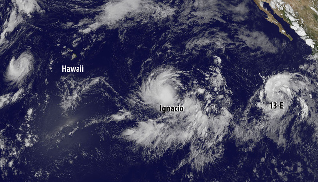
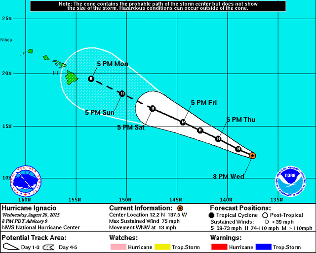
Hurricane Ignacio is expected to approach the Big Island as a Category 1 storm Monday evening.
Ignacio, the seventh hurricane and ninth named storm of the Eastern Pacific hurricane season, was located 1,275 miles east-southeast of the Big Island and tracking toward the west-northwest at 13 mph as of Wednesday evening, forecasters with the National Hurricane Center said. It had maximum sustained winds of 75 mph that extended outward up to 25 mph from the center of the storm. Tropical storm-force winds extended 60 miles from the center.
Continued strengthening is forecast through Friday as Ignacio passes through a moist environment and over warm waters of about 82 to 84 degrees. The storm is expected to peak as a Category 2 storm packing 115 mph winds Friday less than 800 miles east of the Big Island.
Thereafter, vertical shear and cooler waters are expected to weaken the cyclone, forecasters said. However, it will still remain a hurricane as it approaches the Big Island.
On Monday evening, should the storm follow its current forecast track, Ignacio is expected to be a Category 1 hurricane packing 85 mph winds about 100 miles east of the Hilo.
Forecasters continue to caution, however, that there remains uncertainty as to how intact a ridge that often steers storms south or north of the islands will remain.
“Between the various models it looks like some pull it north and some pull it south,” said National Weather Service Meteorologist Leann Eaton. “Any little shift in the track will create a world of difference.”
Several tropical systems have threatened Hawaii during the past weeks; most of them have changed course and/or weakened before reaching the Big Island.
But, even if the storm track takes Ignacio north or south of the Big Island, impacts will likely be felt, Eaton said, pointing to then-Tropical Depression Kilo, which passed hundreds of miles south of the island yet resulted in flooding incidents.
“Kilo had no direct impact to the Hawaiian Islands, but it did pull over some of the moist tropical air and we could see that again,” Eaton said.
Meanwhile in the Eastern Pacific, Tropical Depression 13-E formed Wednesday morning more than 800 miles south-southwest of the southern tip of the Baja California peninsula. As of 5 p.m., it featured maximum sustained winds of 35 mph and was traveling toward the west at 17 mph.
The depression is expected to strengthen in the coming days, fueled by low shear, very warm waters and a moist atmosphere. Forecasters are calling for the disturbance to reach tropical storm strength Thursday, at which time it will be named Jimena, and hurricane strength on Friday.
It could be upgraded to a Category 3 or 4 storm by early next week when it is about 1,200 miles east of the Big Island. A Category 3 storm packs winds of 111 to 129 mph while a Category 4 story has maximum sustained winds of 156 mph. Both are considered to be a major hurricane capable of causing extensive damage.
Forecasters are also monitoring two cyclones far west of the state.
Tropical Storm Kilo, located 770 miles west of Kailua-Kona, had maximum sustained winds of 50 mph with higher gusts and was traveling southwest at 3 mph. Kilo is forecast to continue strengthening and could become a hurricane this weekend.
Tropical Storm Loke was packing 60 mph winds and traveling toward the northwest at 36 mph, forecasters said. Located nearly 1,700 miles northwest of Kailua-Kona, the storm was expected to begin weakening Wednesday evening.
Elsewhere in the Central North Pacific, no tropical cyclones are expected through Friday afternoon.
Many factors effect the level of tropical cyclone activity from year to year. Among them are El Nino, which correlates with warmer ocean temperatures and reduced vertical shear that can cause increased storm activity, and La Nina, which features cooler waters and historically has produced below normal activity seasons. Warmer waters fuel convection and storms.
Currently, the Central North Pacific Ocean Basin is experiencing El Nino conditions that are forecast to continue through at least winter, and possibly longer.
Forecasters, at the start of the season, called for an above-normal season with five to eight tropical cyclones — a category that includes tropical depressions, tropical storms and hurricanes — expected to impact the basin this year. On average, the basin annually sees four to five tropical cyclones in its waters.
So far this season, seven tropical cyclones have either formed or passed through the basin. Several of those storms formed in the Eastern Pacific basin before crossing into the Central North Pacific basin.
Last year, forecasters also called for an above-normal season with four to seven tropical cyclones forecast to pass through the Central Pacific. During the season, Wali, Genevieve, Iselle, Julio and Ana traversed its boundaries.
In the Eastern Pacific basin, which extends east of 140 longitude west to North America, forecasters called for 15 to 22 named storms.
The Central North and Eastern Pacific hurricane seasons run through Nov. 30.
Get more hurricane-related content, including preparation tips, evacuation info and daily tropical weather updates, on our hurricane season page, sponsored by Clark Realty, at www.westhawaiitoday.com/hurricane-season-2015.


