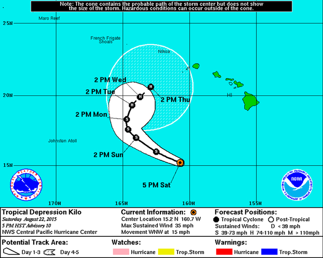
A weakening Tropical Depression Kilo kept the islands under a flash flood watch on Saturday, with a mass of saturated air to the northeast of the storm spreading across the lower archipelago. A still highly unpredictable system has the potential to develop into a Category 2 hurricane as it the storm hooks around from the southwest and approaches the state by next weekend.
A weakening Tropical Depression Kilo kept the islands under a flash flood watch on Saturday, with a mass of saturated air to the northeast of the storm spreading across the lower archipelago. A still highly unpredictable system has the potential to develop into a Category 2 hurricane as it the storm hooks around from the southwest and approaches the state by next weekend.
Developing areas of heavy rainfall prompted a flood advisory Saturday afternoon for the northern portion of the island from Captain Cook to Hawi and east to Paauilo. The National Weather Service warned the moisture could interact with local terrain and produce intense, slow-moving downpours through Monday, with 2 to 4 inches of rain possible in some areas over the weekend.
That rainfall was beginning to register on the slopes of Mauna Loa and Mauna Kea above 6,000 feet Saturday, NWS meteorologist Chris Brenchley said.
Kilo was located 420 miles south-southwest of the Big Island with 35 mph winds on Saturday evening. The storm had briefly weakened overnight and its failure to organize had forecasters struggling with the intensity forecast. A higher ocean heat content and weaker sheer after Monday is predicted to allow Kilo to steadily regenerate into hurricane status by mid-week as it muddles slowly along to the northeast in the general direction of Kauai.
Kilo is a wild card, and the steering currents guiding the system five days from now are predicted to be weak. How far the storm turns toward the islands is still highly uncertain, and should be monitored closely by the public, Brenchley said. The atmospheric conditions in its path do not indicate it will weaken beyond Thursday, the point where meteorologists believe Kilo will have strengthened to a 100-mph hurricane.
“Beyond day five still looks favorable for more strengthening,” Brenchley said. “That’s a long way out and a lot can change, which is why we don’t forecast beyond five days. But the water is warm and there’s not much sheer.”
Kilo was trucking west-northwest at 15 mph on Saturday, and its forward motion is expected to slow late Monday as a weakness in a high pressure ridge allows the storm to swing more toward the islands.
The cyclone has had trouble organizing even though it is in an area of 84-degree water and low wind shear. Forecasters caution that an extended forecast on the system’s strength is irrelevant if the storm continues its failure to organize and dissipates in the short term. Kilo was set to experience 12 to 17 mph northwesterly sheer from Saturday through Monday.
A thousand miles west of Kilo, meteorologists are also tracking Tropical Depression Loki, which packed 40 mph winds and was set to gradually intensify this coming week. That system is weaving its way roughly north and is set to pass through the Northwestern Hawaiian Islands near the Pearl and Hermes Atoll on Monday.

