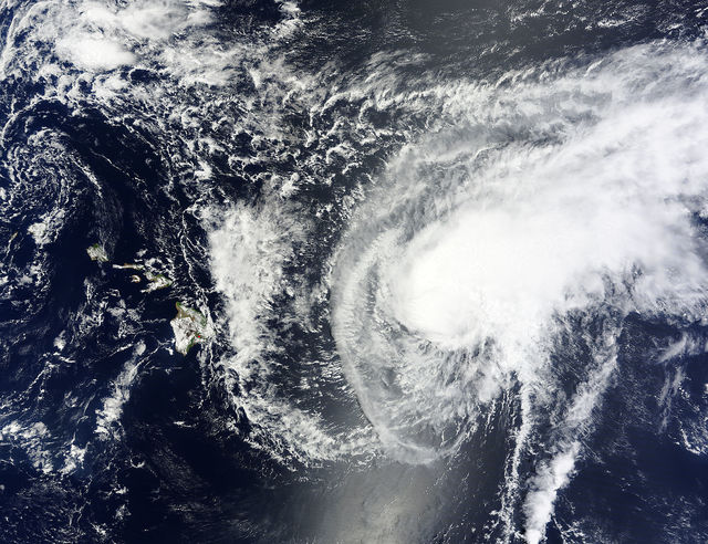
Leeward areas of the Big Island still might see some rainfall through Friday though Tropical Storm Guillermo was expected to pass north of the island Wednesday night.
As Guillermo passes, tradewinds are expected to weaken, resulting in increased afternoon and mauka showers for leeward areas, said Central Pacific Hurricane Center Forecaster Pete Donaldson. Heavy rainfall is also possible for other areas of the island through Friday.
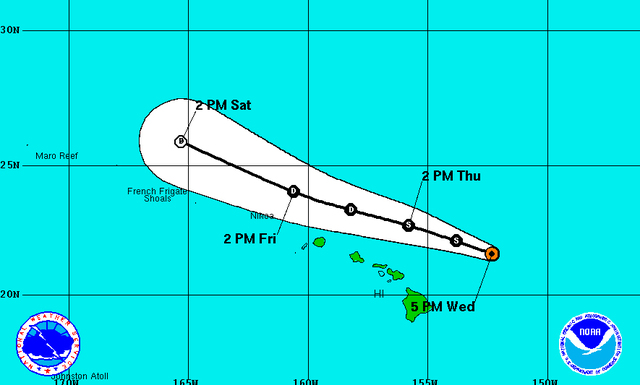
Guillermo was located about 275 miles east-northeast of Kailua-Kona, packing 50 mph winds and moving toward the west-northwest around 10 mph as of Wednesday evening, forecasters said. The tropical cyclone’s center is forecast to pass about 170 miles north of the Big Island Wednesday night and 100 miles north of Oahu on Thursday night.
Tropical storm force winds extend outward up to 175 miles from the center of the storm, with the strongest winds being found mainly northeast of the center of Guillermo, Donaldson said. Tropical storm-force winds were not expected to impact the Big Island.
The Central Pacific Hurricane Center in Honolulu discontinued tropical storm and flash flood watches for the Big Island and Maui County at 11 a.m. Wednesday.
Swells associated with Tropical Storm Guillermo continue produce large surf along east-facing shores of all islands. With wave heights of 10 to 15 feet forecast, the National Weather Service has issued a high surf warning for east-facing shores of the Big Island’s northern, eastern and southern coasts that will remain in effect until 6 p.m. Thursday.
Because of the hazardous conditions, Hawaii County Civil Defense closed Wednesday Onekahakaha Beach Park, Kealoha Beach Park, Leileiwi Beach Park and Richardson Beach Park.
Strong westerly winds are expected to further weaken Guillermo during the coming days. The cyclone should be downgraded to a depression by Thursday night.
Also being monitored Wednesday was an area of showers and thunderstorms associated with a low pressure system about 1,425 miles west-southwest of the southern tip of the Baja California peninsula. Environmental conditions are expected to be conducive for development, and a tropical depression could form Thursday. The low is expected to continue moving westward at 10 to 15 mph and then turn west-northwestward later this week.
The National Hurricane Center gave the disturbance an 80 percent chance of forming into a tropical cyclone within 48 hours.
Several hundred miles east of that disturbance, forecasters are also monitoring a tropical wave south-southwest of the Baja California peninsula that continues to produce disorganized cloudiness and showers. The system could see some development during the next several days.
Get more hurricane-related content, including preparation tips, evacuation info and daily tropical weather updates, on our hurricane season page, sponsored by Clark Realty, at www.westhawaiitoday.com/hurricane-season-2015.


