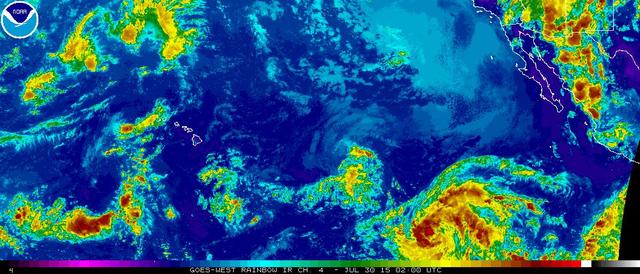
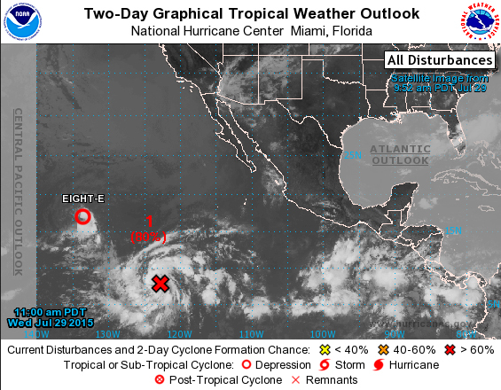
A new tropical depression in the Eastern Pacific is on a course toward the Hawaiian Islands and predicted to strengthen into a hurricane as it approaches early next week.
Tropical Depression Nine E, located 2,200 miles east-southeast of Kona, strengthened quickly into a depression Wednesday evening and was set to become a tropical storm by Thursday morning and a hurricane packing 75 mph winds by Friday. The system was gaining a well-defined center of circulation Wednesday evening with 35 mph winds, while moving west-northwest at about 15 mph.
The long-range predicted track begins to turn north on Sunday before the storm reaches the Hawaiian Islands.
A warm, moist environment, low wind shear and high sea surface temperatures are expected to fuel steady strengthening into the weekend, according to the National Hurricane Center. Nine E is slated to enter the Central North Pacific basin on Saturday. By Monday, the system should be about 600 miles east of Hilo with 75 mph winds and turning north away from the island, according the National Weather Service forecasts.
The waters east and south of Hawaii are around 81 degrees, high enough to sustain a hurricane.
Tropical Depression Eight E, on the other hand, is fading, and is on a course to sputter past well south of the Big Island, likely bringing little effect except an increase in trade winds sucking down from the north into the low pressure system.
Battling wind shear about 1,400 miles east of Hilo, Eight E has failed to strengthen. The depression was headed west at about 16 mph, with 35 mph winds, but drier air and lower ocean heat content were expected to weaken the system into a trough by Friday evening.
Eight E is forecast to be a remnant low by the time it moves south of the Big Island Saturday night or Sunday. At worst, the system is likely to bring no more than increased thunderstorms and shower activity, said John Jelsema, lead forecaster with the Central Pacific Hurricane Center, on Thursday.
The potential for increased trade winds is in contrast to recent dissipated tropical storms Ela and Enrique, which passed north of the state earlier this month, cutting off the trades and smothering the state with humidity.
Eight E may kick up some swell — but it won’t be on the scale seen earlier this week on the island, Jelsema said. That train of waves beginning over the weekend and lasting several days was generated by a massive storm near New Zealand that pushed winds and 6- to 8-foot south swell toward Hawaii.
In all, tropical cyclone activity has been high in the Eastern Pacific this month. The body of water off the coast of Mexico was host to record setting hurricane activity in June, with three hurricanes — two of them major. The systems all stayed fairly close to the mainland and tracked northwest.
Hurricane expert Eric Blake with the National Hurricane Center in Florida tweeted on Thursday that sea surface temperatures in the northwest portion of the Eastern Pacific are at record levels. Some scientists say this year’s El Nino could break records by the time it peaks in strength later this year.
Get more hurricane-related content, including preparation tips, evacuation info and daily tropical weather updates, on our hurricane season page, sponsored by Clark Realty, at www.westhawaiitoday.com/hurricane-season-2015.


