It’s time to prepare, Big Island, for the possibility of a hurricane season redo. ADVERTISING It’s time to prepare, Big Island, for the possibility of a hurricane season redo. Scientists and meteorologists who sort through tangles of water temperature and
It’s time to prepare, Big Island, for the possibility of a hurricane season redo.
Scientists and meteorologists who sort through tangles of water temperature and wind data are offering a sober prospectus for the coming season. A strengthening El Nino is putting Hawaii on course to contend with conditions that could match or surpass 1997, one of the strongest El Nino on record.
“At least four out of the seven weather models predict stronger El Nino conditions for 2015 than those that occurred in 1997-98,” said Axel Timmermann, an oceanographer and El Nino researcher with the International Pacific Research Center in Honolulu.
The cyclical weather phenomenon, dubbed “The Child” for its tendency to be noticed along the South American coast around Christmas — increases the likelihood of Pacific hurricanes by reducing wind shear and increasing the water temperatures that fuel the giant heat engines. Here’s a snapshot of what El Nino helped produce in the 1997 Pacific hurricane season: 17 named storms and 10 hurricanes — seven of them major hurricanes and two of them Category 5 cyclones. Nine cyclones entered or formed in the Central North Pacific basin, with the last one spawned just before Christmas, 21 days after the season normally ends.
El Nino also helped increase hurricanes in the Central Pacific in 1992 and 1994, years which both had 11 cyclones.
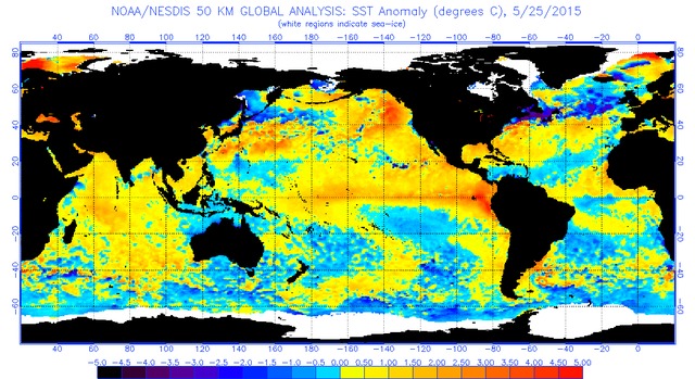
Even though waters to the east and south of Hawaii are an average of 77 degrees — not yet warm enough to sustain hurricane development — there are signs that could spell trouble as temperatures increase going into summer.
“There is an unusual warming south of Hawaii and all the way toward Baja California. Furthermore, the thermocline ridge — that usually puts a break to hurricane growth in the eastern tropical Pacific — seems to have disappeared,” Timmermann said. “Both factors could increase the number of hurricanes in the eastern tropical Pacific. There is a chance that warm water south and east of Hawaii may lure more hurricanes toward Hawaii — similar to the situation last year.”
Forecaster Derek Wroe was on Memorial Day weekend duty at the National Weather Service in Honolulu last Saturday, watching two disturbances as they slowly organize themselves, only to quickly deteriorate before reaching cyclone status. The closest was about 1,600 miles southeast of the Big Island. Wroe noted that it was unusual to see the activity so far west and close to Hawaii this time of year. But it’s not surprising, given an unusually warm body of water in that region.
“It’s time to dust off your hurricane plan,” Wroe said. “And if you don’t have one, it may be time to start thinking about creating one and asking yourself, what would you do in a hurricane?”
Tom Evans, acting director of the Central Pacific Hurricane Center, said each family should prepare for the season.
“The whole idea is to have an emergency kit, have a plan, practice it, and stay informed,” Evans said. “The idea here is to be weather-ready. It only takes one tropical cyclone to have a devastating effect on your island.”
There is no need to look too deep into history for perspective on what El Nino-like conditions can help create for Hawaii. Last year, warm water helped generate 20 named storms in the eastern Pacific, the highest number since 1992, when Hurricane Iniki plastered Kauai with 140 mph winds. In 2014, Tropical Storm Iselle hit the Big Island squarely, and Hurricane Ana stewed in the Central Pacific Basin longer than any other hurricane that’s passed through the region. Additionally, the island chain was threatened by two unprecedented back-to-back hurricanes, Iselle and Julio.
Last year’s warmer waters were an indicator of El Nino, although other climatic benchmarks didn’t come together well enough for observing scientists to declare an actual event. This year, El Nino factors are coming together in force, with all the bells and whistles scientists look for — including a tell-tale increase in westerly winds and a weakening of equatorial trade winds.
Weather models predict the east equatorial Pacific waters — already an average 2 degrees above normal — will peak somewhere around 4 to 5 degrees above normal in fall, then slowly decrease through winter. The change typically lasts nine to 12 months, but can extend longer.
The increase in surface temperatures, giving storms more fuel in the form of heat, is probably El Nino’s biggest contribution to hurricane formation. But its effects on wind shear are also important. El Nino changes wind patterns, in the process creating broad areas of weakened shear, making it easier for hurricanes to stay intact. Vertical shear — changes in wind speed and direction at various elevations in the atmosphere — is one of the biggest enemies of cyclones, which must be vertically stacked to maintain their force.
Hawaii has traditionally been somewhat insulated from hurricanes by at least two factors, marginal sea surface temperatures and generally strong wind shear. The hurricanes tend to intensify in areas of warmer water and weaker shear in the eastern Pacific. As they truck west and lose steam in the cooler waters around Hawaii, they also encounter increased shear and are shredded by the conflicting layers of air currents.
The Aloha State may not have the luxury of relying on those protections this time around.


